|
|
||||||||||||||||||||
Colli Albani or Alban Hills volcanic complex, Latium, Italy volcano number: 0101-004 (according to Volcanoes of the World, 1994 edition) summit elevation: 949 m location: 41.73�N, 12.70�E
|
||||||||||||||||||||
|
|
||||||||||||||||||||
| Introduction
|
||||||||||||||||||||
|
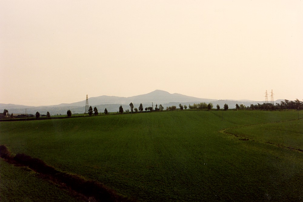
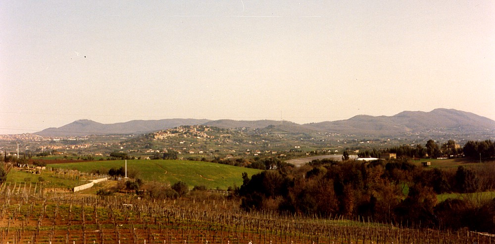
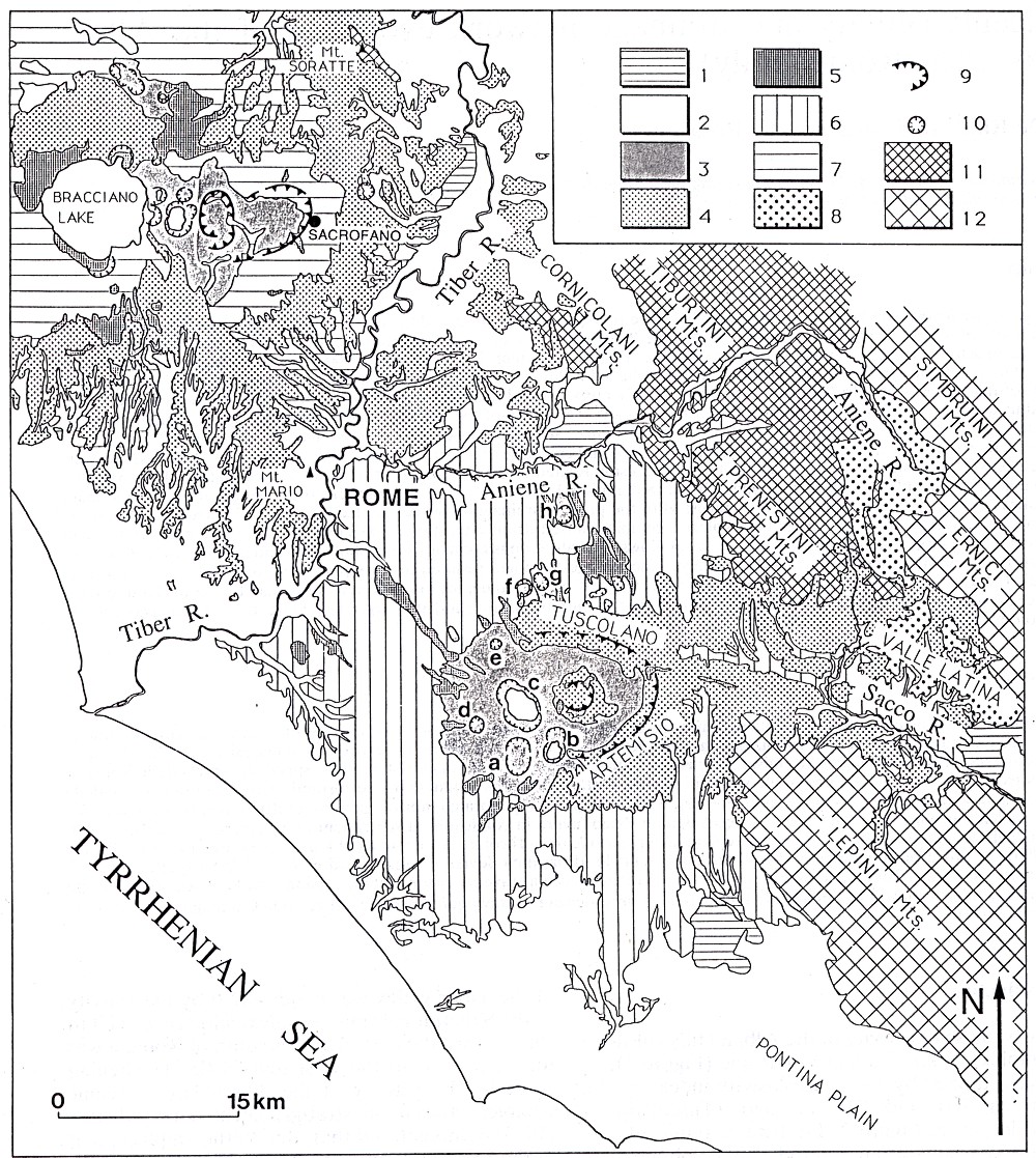
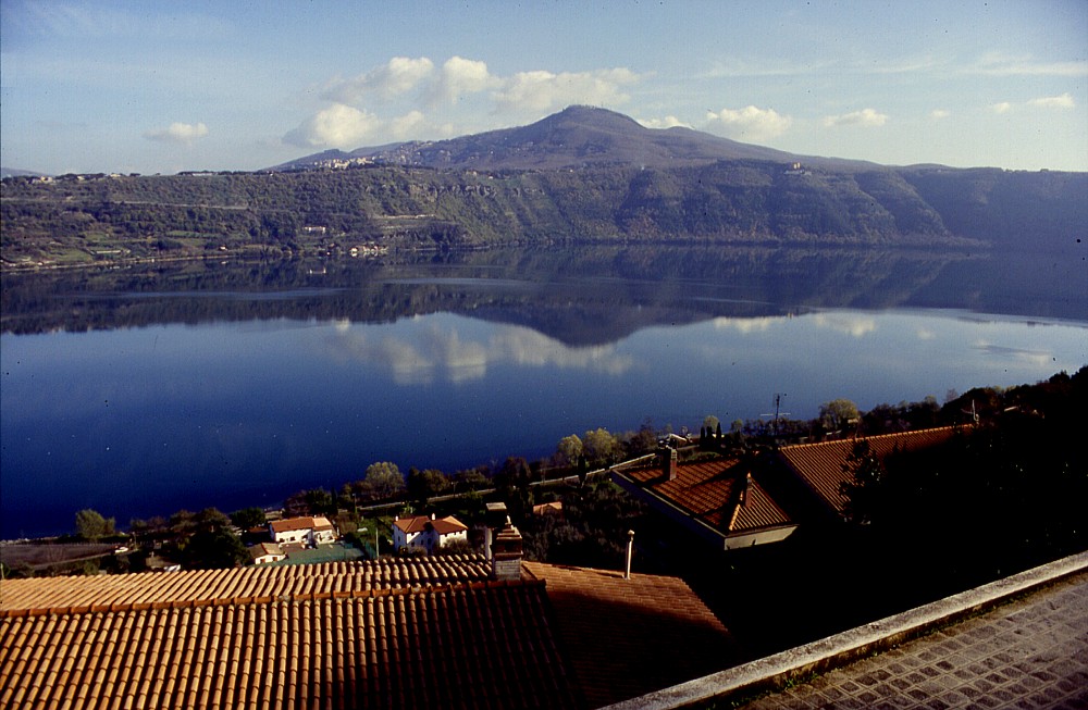
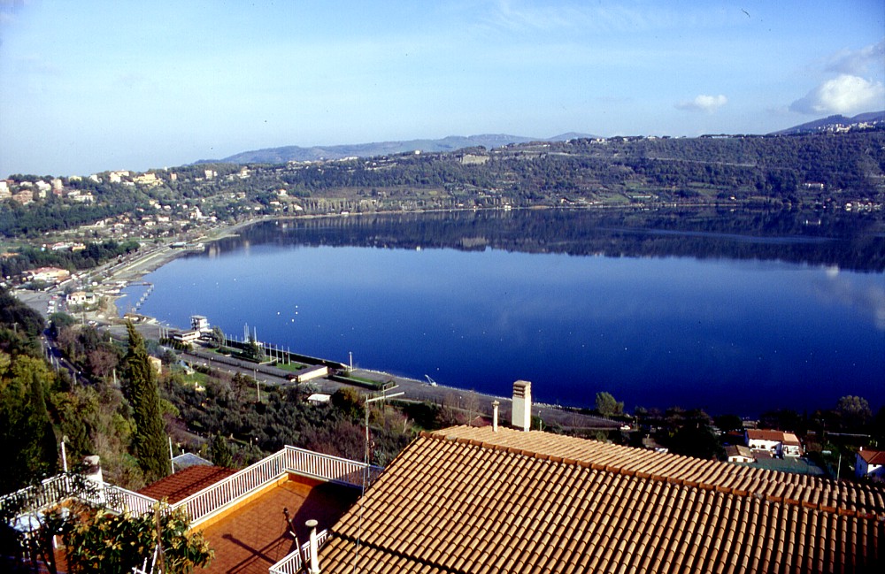
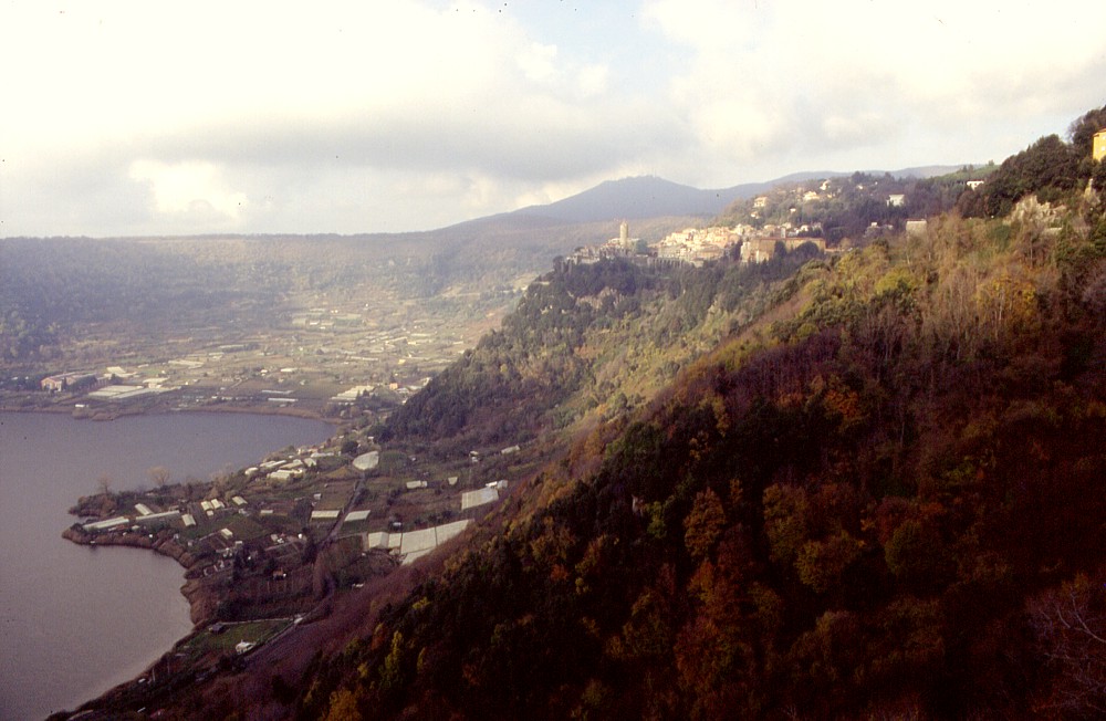
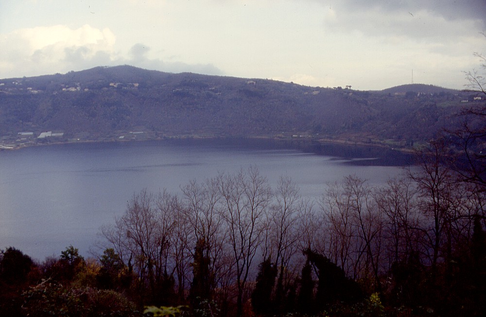
The Colli Albani volcanic complex, also known as the "Vulcano Laziale" or the Alban Hills volcano, forms a prominent feature on the southeastern skyline of Roma. The structure of this "somma" type volcano (caldera with a central cone) is much more complex than it seems from a distance. Indeed, the volcano has two nested calderas and numerous more or less eccentric post-caldera vents, most of which are explosion craters. The highest point of the Colli Albani is Monte Cavo (949 m), a scoria cone sitting eccentrically on the SW rim of the younger Faete caldera. There are two crater lakes, Albano and Nemi which fill the most recent craters of the volcano. Lago Albano, with its lake level at 293 m elevation, is 170 m deep and thus the deepest of all volcanic lakes in the Central Italian volcanic region (also known as the Roman Comagmatic region). Lago di Nemi lies somewhat higher (lake level at 316 m) but is very shallow. Even these late-stage explosion craters, despite their apparently simple morphology, have gone through a complex evolution. Today, they constitute an extremely scenic landscape, which hosts the summer residence of the Pope at Castel Gandolfo, right on the rim of the crater that contains Albano Lake, and is a quite popular weekend destination for numerous Romans. The volcanic complex is relatively densely populated, and the outskirts of Rome extend to its northern base, including an airport. Much of Rome itself stands on the products of the Pleistocene explosive volcanic activity of the Colli Albani. In spite of frequent seismicity (Amato et al. 1994), the Colli Albani have until recently been considered an "extinct" volcano - in the sense that no future eruptions had to be expected, in spite of historical documents indicating some kind of eruptive activity as recently as 114 B.C. This alleged eruptive activity was discredited by geological studies of the early 1960s (Fornaseri et al. 1963) to late 1980s (De Rita et al. 1988), which indicated that all deposits of the Colli Albani were older than Holocene (>10,000 years). A detailed study of historical documents by Stothers and Rampino (1983) led them to consider the reports on an eruptive event in 114 B.C. not trustworthy and thus seemed to confirm the apparent geological evidence.However, since the mid-1990s increasing evidence for ongoing volcanic unrest has been detected (Amato and Chiarabba 1995; Chiarabba et al. 1997; Anzidei et al. 1998), and the most recent research indicates that there has been eruptive activity during the Holocene indeed (Funiciello et al. 2003; Porreca et al. 2003), as indicated already a few years earlier by some researchers (Villa et al. 1999). Based on studies of the long-term behavior of the volcanic complex and on regional tectonic evidence, Karner et al. (2001a, b) and Marra et al. (2003) arrive at the conclusion that the volcano might be just at the beginning of a new eruptive phase, thus supporting the other evidence. The presence of a potentially active volcano at only 25-30 km from the center of Rome certainly is not exactly reassuring, and the new findings have stimulated a wave of intense study which will result in a completely revised concept of volcanic hazards in the area of the "Eternal City".
Geological evolution
In recent years, the Colli Albani have been the subject of numerous
geological studies, which focused mainly on the lithological, facies
and compositional properties of certain eruptive events, and on unraveling
the most recent geological history of the volcanic complex. Recently,
competition between two simultaneously working groups of scientists
makes it slightly difficult to summarize their findings, and the following
basically summarized the findings of the two groups, trying to correlate
them as precisely as possible.
After a brief period of volcanic quiescence, activity resumed in the central area of the caldera where a new small stratovolcano was constructed (Campi di Annibale or Faete epoch). This epoch is also subdivided into cycles, but the significance of the eruptions and erupted volumes were much less than during the Tuscolano-Artemisio epoch. The total volume of erupted products of the Campo di Annibale-Faete epoch is only 2 km3, compared to about 283 km3 of the Tuscolano-Artemisio volcanics. One of the most important products of this epoch is the Capo di Bove lava flow, which is morphologically very distinct and is cut by the GRA (Grande Raccordo Anulare, the outer ring freeway that goes all the way round the city of Rome). The Campi di Annibale-Faete epoch lasted from about 277 ka until about 250 ka (Watkins et al. 2002; Funiciello et al. 2003).
The most recent activity of the Colli Albani, previously coined the
final hydromagmatic phase (De Rita et al. 1988), has been recently re-named
"Phreatomagmatic epoch" by Funiciello et al. (2003). Karner
et al. (2001a) named what was interpreted by them as the main deposit
of this epoch"Peperino di Marino (Lapis Albanus)". It began
after a period of repose of more than 200,000 years, at about 45 ka.
During this epoch, hydromagmatic eruptions occurred from several eccentric
craters (maars), mostly in the NW and SW sectors of the volcanic complex,
such as the lake-filled maar craters of Nemi and Albano and several
less-known dry depressions. Among these craters, the one now filled
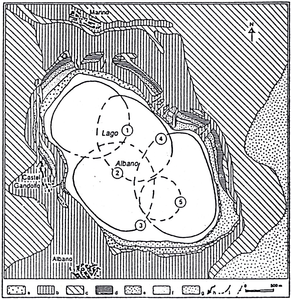
with the scenic Albano Lake seems to have undergone the most complex
evolution (Villa et al. 1999), with at least five distinct eruptive
centers (I to V; see geological sketch map of the Albano crater above)
erupting in the area now occupied by the lake. The first of these eruptive
centers (I) probably erupted about 45 ka ago, the third (III) about
26 ka ago, and the fourth might have been active about 16 ka ago. The
youngest of the Albano crater vents, which coincides with the deepest
portion of the lake, may be as young as 7.5 ka (Villa et al. 1999). A Holocene age of the latest eruptions and other geological events that would provoke catastrophic effects, were they to occur today, has been confirmed by fieldwork at the beginning of the new millennium conducted by Funiciello et al. (2002, 2003) and Porreca et al. (2003). These authors recognized that the ~25 ka "Peperino Albano" is not the youngest eruptive product of the volcano. During fieldwork in outcrops opened during the construction of new roads in the ever more populated northwestern sector of the volcano, they discovered the deposits of phreatomagmatic activity and lahars, which extend up to 15 km from the vent, right into the southeastern outskirts of Rome. Porreca et al. (2003) determined an emplacement temperature of more than 200°C for a pyroclastic density current deposit in the newly discovered succession. A paleosoil separating this deposit from overlying lahar deposits has been dated at 5100±100 years before present (Funiciello et al. 2003). Further deposits stemming from the catastrophic overspilling of water (convective rollover) from the crater lake (whose level stood much higher until the Roman era than at present; drainage work carried out by the Romans in the 4th century B.C. brought the lake level to its present elevation) make up the uppermost portion of the succession. Funiciello et al. (2002, 2003) suggest that these overspills were caused by the sudden release of large quantities of hot fluids rich in CO2 into the lake, which occurred as a consequence of seismically induced microfracturing. Until
very recently, the Colli Albani has generally been considered an inactive
volcano (especially after records of activity in historical sources
were discarded by various researchers, such as Stothers & Rampino 1983).
The recent research leads to conclusions that are contrary to that reassuring
belief. While some authors fear that the lastest eruptions at the Albano
crater and other explosion craters has just been the beginning of a
new phase of activity (Karner et al. 2001a, b; Marra et al. 2003), others
simply point out that catastrophic lahars and minor phreatomagmatic
activity have continued until much more recently than previously assumed
(Funiciello et al. 2003). Furthermore, the volcano is seismically active,
with several notable earthquake swarms since the early 1980's, and it
was only in the early 1990s that a significant amout of very recent
ground uplift was detected (Amato and Chiarabba 1995), whose maximum
coincides precisely with the central area of the volcanic complex. This
uplift continued at least through 1997, as indicated on the Colli
Albani web site of the Rome section of the Istituto Nazionale di
Geofisica e Vulcanologia.
References Amato A, Chiarabba C (1995) Recent uplift of the Alban Hills Volcano (Italy): evidence for magmatic inflation? Geophysical Research Letters 22: 1985-1988 Amato A, Chiarabba C, Cocco M, Di Bona M, Selvaggi G (1994) The 1989-1990 seismic swarm in the Alban Hills volcanic area, central Italy. Journal of Volcanology and Geothermal Research 61: 225-237 Annunziatellis A, Ciotoli G, Lombardi S, Nolasco F (2003) Short- and long-term gas hazard: the release of toxic gases in the Alban Hills volcanic area (central Italy). Journal of Geochemical Exploration 77: 93-108 Anzidei M, Baldi P, Casula G, Galvani A, Riguzzi F, Zanutta A (1998) Evidence of active crustal deformation of the Colli Albani volcanic area (central Italy) by GPS surveys. Journal of Volcanology and Geothermal Research 80: 55-65 Beaubien SE, Ciotoli G, Lombardi S (2003) Carbon dioxide and radon gas hazard in the Alban Hills area (central Italy). Journal of Volcanology and Geothermal Research 123: 63-80 Carapezza ML, Badalamenti B, Cavara L, Scalzo A (2003) Gas hazard assessment in a densely inhabited area of Colli Albani Volcano (Cava dei Selci, Roma). Journal of Volcanology and Geothermal Research 123: 81-94 Chiarabba C, Amato A, Delaney PT (1997) Crustal structure, evolution, and volcanic unrest of the Alban Hills, Central Italy. Bulletin of Volcanology 59: 161-170 Chiodini G, Frondini F (2001) Carbon dioxide degassing from the Alban Hills volcanic region, Central Italy. Chemical Geology 177: 67-83 De Rita D, Funiciello R, Parotto M (1988) Carta Geologica del Complesso vulcanico dei Colli Albani (Geological map of the Colli Albani volcanic complex), scale 1:50,000, Consiglio Nazionale delle Ricerche De Rita D, Funiciello R, Rosa C (1992) Volcanic activity and drainage network evolution of the Alban Hills area (Rome, Italy). Acta Vulcanologica 2: 185-198 De Rita D, Giordano G, Esposito A, Fabbri M, Rodani S (2002) Large volume phreatomagmatic ignimbrites from the Colli Albani volcano (Middle Pleistocene, Italy). Journal of Volcanology and Geothermal Research 118: 77-98 Fornaseri M, Scherillo A, Ventriglia U (1963) La regione vulcanica dei Colli Albani (Vulcano Laziale). Consiglio Nazioale delle Ricerche Roma, 550 pages Funiciello R, Giordano G, De Rita D, Carapezza ML, Barberi F (2002) L'attività recente del cratere del Lago Algano di Castelgandolfo. Rendiconti dell'Accademia dei Lincei (Scienze Fisiche e Naturali) ser. 9, 13: 113-143 Funiciello R, Giordano G, De Rita D (2003) The Albano maar lake (Colli Albani Volcano, Italy): recent volcanic activity and evidence of pre-Roman Age catastrophic lahar events. Journal of Volcanology and Geothermal Research 123: 43-61 Giordano G, De Rita D, Cas RAF (2002a) Valley pond and ignimbrite veneer deposits in the small-volume phreatomagmatic 'Peperino Albano' basic ignimbrite, Lago Albano maar, Colli Albani volcano, Italy: influence of topography. Journal of Volcanology and Geothermal Research 107: 131-144 Giordano G, De Rita D, Fabbri M, Rodani S (2002b) Facies associations of rain-generated versus crater lake-withdrawal lahar deposits from Quaternary volcanoes, central Italy. Journal of Volcanology and Geothermal Research 118: 145-159 Karner DB, Marra F, Renne PR (2001a) The history of the Monti Sabatini and Alban Hills volcanoes: groundwork for assessing volcanic-tectonic hazards for Rome. Journal of Volcanology and Geothermal Research 107: 185-219 Karner DB, Marra F, Florindo F, Boschi E (2001b) Pulsed uplift estimated from terrace elevations in the coast of Rome: evidence for a new phase of volcanic activity? Earth and Planetary Science Letters 188: 135-148 Marra F, Freda C, Scarlato P, Taddeucci J, Karner DB, Renne PR, Gaeta M, Palladino DM, Trigila R, Cavarretta G (2003) Post-caldera activity in the Albani Hills volcanic district (Italy): 4040Ar/39Ar geochronology and insights into magma evolution. Bulletin of Volcanology 65: 227-247, DOI: 10.1007/s00445-002-0255-9 Palladino DM, Gaeta M, Marra F (2001) A large K-foiditic hydromagmatic eruption from the early activity of the Alban Hills Volcanic District, Italy. Bulletin of Volcanology 63: 345-359, DOI: 10.1007/s004450100150 Porreca M, Mattei M, Giordano G, De Rita D, Funiciello R (2003) Magnetic fabric and implications for pyroclastic flow and lahar emplacement, Albano maar, Italy. Journal of Geophysical Research 108, DOI 10.1029/2002JB002102 Trigila R (editor) (1995) The volcano of the Alban Hills. Tipografia SGS, Rome, 283 pages Villa IM, Calanchi N, Dinelli E, Lucchini F (1999) Age and evolution of the Albano crater lake (Roman Volcanic Province). Acta Vulcanologica 11: 305-310 Web sites The GPS network maintained by the Istituto Nazionale di Geofisica e Vulcanologia (INGV) at the Colli Albani (in Italian) An
Italian web site describing the lakes of the Latium region (many of
them filling volcanic depressions such as explosion craters and calderas)
has information and photos of Albano
Lake and Lake Nemi |
||||||||||||||||||||
| Copyright © Boris Behncke, "Italy's Volcanoes: The Cradle of Volcanology" |
||||||||||||||||||||
| Page
set up on 26 June 1996, last modified on 8 August 2003 |
||||||||||||||||||||