![]()

| Monte
Amiata index |
||
| Geology | References | Web sites |
|
|
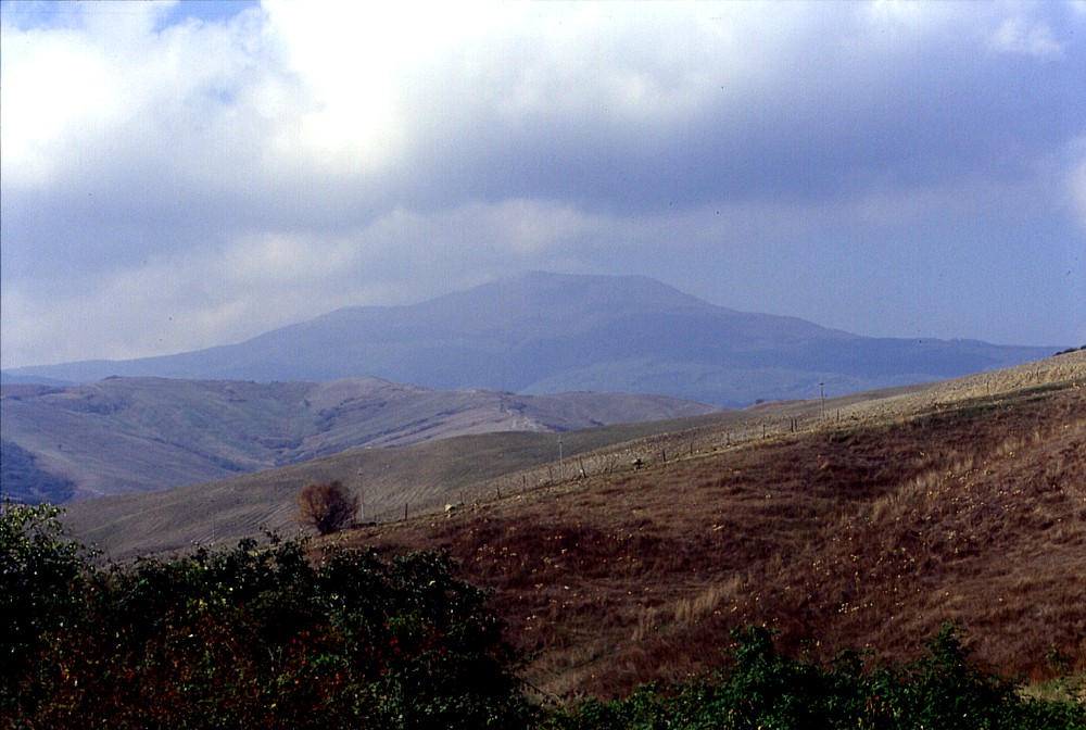
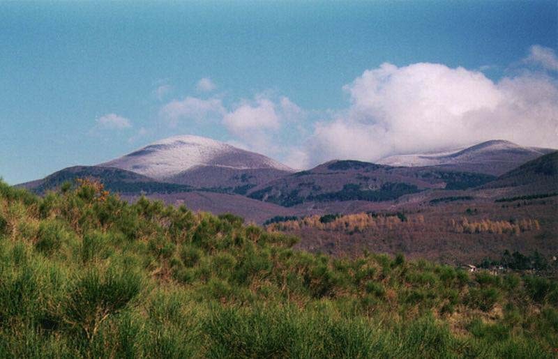
The
bulky cone of Monte Amiata, seen from the east in September 2001.
This mountain, which probably has not erupted since about 180,000
years, is the second tallest among Italy's volcanoes (Mount Etna
is nearly twice as tall), but the volcanic edifice stands on a plateau
at more than 1000 m elevation, and thus is only 600 m high |
Monte Amiata volcano, Tuscany, Italy
volcano number: 0101-002 (according to Volcanoes of the World, 1994 edition)
summit elevation: 1738 m
location: XX.XX�N, XX.XX�E
![]()
Monte Amiata (with a summit elevation of 1738 m the highest mountain in the Tuscany region, and the second tallest volcano in Italy) is probably the least known of the major Italian central volcanoes and volcanic complexes. It lies in the southernmost part of Tuscany, close to the boundary with Latium, only a few tens of kilometers to the north of the Vulsini volcanic complex. The area is remote and not as touristically tormented as much of the rest of Tuscany. There are no large population centers within about 50 km from the volcano. The surrounding landscape is densely forested and consists of a series of roughly NW-SE trending ridges and valleys.
Monte Amiata is a late Quaternary (until ca. 180 ka ago) complex mainly formed of ignimbrite sheets and trachytic lava domes and flows, with very subordinate more mafic lava flows erupted late in the activity. The volcanic area of Monte Amiata is roughly 85 km2, the thickness of the volcanic pile reaching up to 600 m. Geothermal activity is still occurring at Monte Amiata (the Bagnore steam vents) which is used for geothermal energy production..
The activity of Monte Amiata during its main stage consisted of voluminous eruptions of rhyodacitic ignimbrites which show rheomorphism (i.e. flow of still-fluid ignimbrite immediately after emplacement). This activity was accompanied or followed by the formation of at least eight major lava domes along the main tectonic trends (that is, SW-NE and NNW-SSE). The latest significant rhyolitic activity in the Monte Amiata area was the emplacement of one large and two smaller flows, the larger one (south of the summit) reaching a length of 5 km while being up to 4 km wide. Smaller flows of more mafic (trachytic to latitic) lava were erupted during the last activity, mainly on the E flank of the summit lava dome.
Ferrari
et al. (1996) subdivide the activity of Monte Amiata in two main phases
(The Basal Trachydacite Complex, BTC, and Domes and Lava flow Complex,
DLC) and a final phase when olivine latitic lava flows were emitted (OLL).
The deposits of the first phase are a lower massive unit evenly distributed
around the volcano, and an upper unit that forms two distinct tongues
and consists of loose blocks. The volume of the BTC is estimated by Ferrari
et al. (1996) at 13.5-18 cubic km. Its origin has been discussed by various
authors, one group (Rittmann 1958; Marinelli 1961) interpreting it as
a rheoignimbrite while Barberi (1971) believed it was made of lava flows.
Ferrari et al. (1996) take the presence of flow banding structures as
well as the high degree of fragmentation of crystals in the deposit as
evidence that it might result from a fragmental flow and might therefore
be an ignimbrite emplaced at very high temperature, as a single flow unit.
However these authors underline that the question still remains somewhat
unresolved.
The overlying "DLC"
unit consists of lava domes and short viscous lava flows which were K/Ar
dated at 207+/-10 and 190+/-23 ka. Ferrari et al. (1996) distinguish nine
dome and flow units, all except one lying on a fracture orientated ENE-WSW.
The final "OLL" lava flows form two small lobes distinctly different in
terms of mineralogy and chemical composition from the earlier erupted
products. The longer of these two flows, named Ermeta lava, has a length
of 2.5 km. K/Ar ages obtained for these flows overlap with those of the
stratigraphically older domes and lava flows.
Although Monte Amiata does not exhibit any signs of forthcoming activity, there is continuing seismicity in the area (a seismic swarm occurred as recently as 1977).
 |
 |
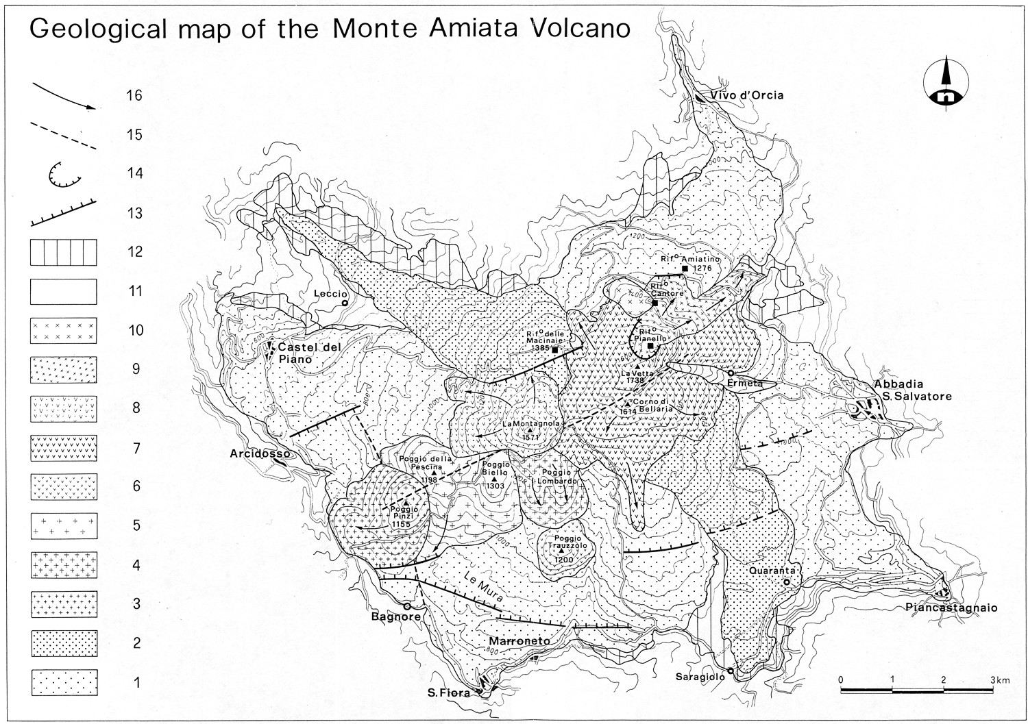
Left:
simplified
geological map of Monte Amiata (from Ferrari et al., 1996). Key:
1=Basal Trachydacitic Complex, lower unit; 2=Basal Trachydacitic
Complex, upper unit; 3=Dome and Lava flow Complex, Poggio Pinzi
unit; 4=Dome and Lava flow Complex, Poggio Lombardo unit;
5=Dome and Lava flow Complex, Poggio Biello unit; 6=Dome
and Lava flow Complex, Poggio Trauzzolo unit; 7=Dome and
Lava flow Complex, La Vetta unit; 8=Dome and Lava flow
Complex, La Montagnola unit; 9=Dome and Lava flow Complex,
Pianello unit; 10=Dome and Lava flow Complex, Cantore
unit; 11=Olivine Latite Lava flows; 12=volcanic detrital cover;
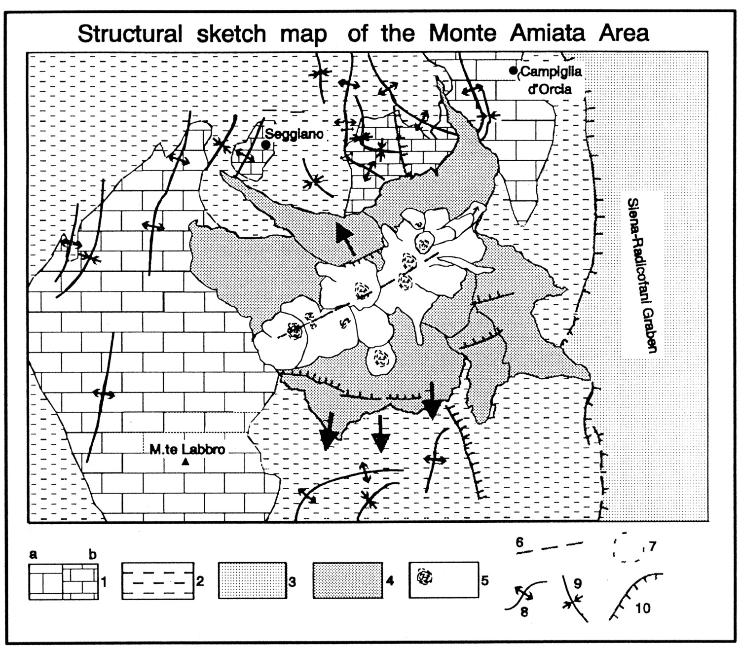
13=fauts; 14=collapsed areas; 15=inferred faults; 16=flow directions Right: simplified structural map of Monte Amiata (from Ferrari et al., 1996). Key (abridged from original caption): 1a=sandstone of the Pietraforte Group underlain by largely carbonatic rocks of the Tuscan sequence; 1b=sandstone of the Pietraforte Group thrust over shales and marly sandstones of same Group; 2=shales and subordinate marly limestones, marls and sandstones of Pietraforte Group; 3=early Pliocene to Quaternary deposits filling Radicofani graben; 4=Basal Trachydacitic Complex; 5=Domes and Lava flow Complex; 6=Olivine Latite Lava flows; 6=feeder fissure; 7=inferred craters; 8=anticline fold axis; 9=syncline fold axis; 10=normal fault |
|
 |
 |
 |
|
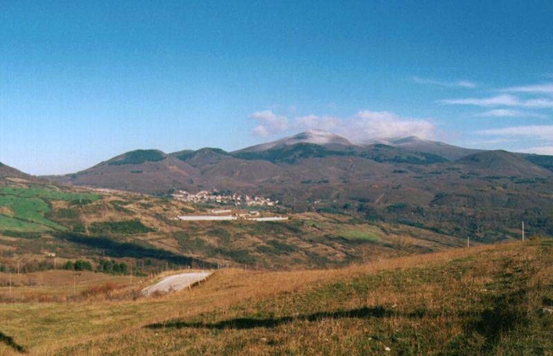
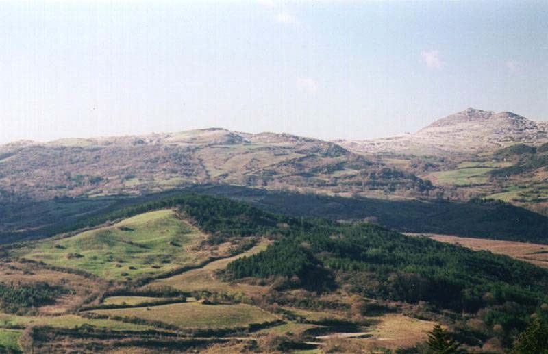
Left:
Monte Amiata seen from southwest on 1 December 1996. The lower hills
at left and at right are lava domes belonging to the Amiata complex.
Note light dusting of snow in the summit region. Photo taken by
Reinhard Lampe (Germany) Center: another view of the snow-covered summit domes of Monte Amiata from southwest, 1 December 1996. Photo taken by Reinhard Lampe (Germany) Right: Monte Labbro, a dome-shaped hill made of carbonate rock on the SW side of Monte Amiata, seen from the east, 1 December 1996 |
||
 |
 |
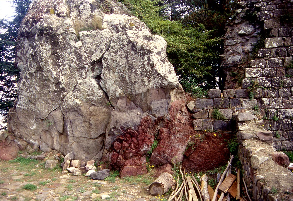 |
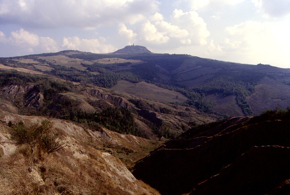
| Left:
Distant view from south of the conspicuous neck of Radicofani in
September 2001. This remainder of a once much larger volcanic center
is surrounded by a landscape dominated by the clayey rocks outcropping
at the surface, and erosion of the relatively infertile terrain
leads to the formation of badlands in many places Center: closer view, from southeast, of the Radicofani neck with the scenic fortress standing on its summit, and the village of Radicofani lying at its base (at left) Right: Outcrop of reddish oxidized scoriae underlying light gray lava on the top of the Radicofani neck, with some of the walls of the fortress ruins visible at right, September 2001 |
||
References
Barberi F, Innocenti F and Ricci CA (1971) La Toscana meridionale. Il magmatismo. Rendiconti della Società Italiana di Mineralogia e Petrologia 27: 169-210
Ferrari L, Conticelli S, Burlamacchi L, Manetti P (1996) Volcanological evolution of the Monte Amiata, Southern Tuscany: New geological and petrochemical data. Acta Vulcanologica 8: 41-56
Marinelli G (1961) Genesi e classificazione delle vulcaniti recenti toscane. Atti della Società Toscana di Scienze Naturali, Memoria 68: 74-116
Pichler H (1970) Italienische Vulkangebiete, I. Sammlung Geologischer Führer, Gebrüder Borntraeger Stuttgart
Web sites
The GPS network maintained by the Istituto Nazionale di Geofisica e Vulcanologia (INGV) at the Colli Albani (in Italian)
An
Italian web site describing the lakes of the Latium region (many of them
filling volcanic depressions such as explosion craters and calderas) has
information and photos of Albano
Lake and Lake Nemi
Copyright © Boris Behncke, "Italy's Volcanoes: The Cradle of Volcanology"