
| Etna
index |
||
| Geology | Geological history | Cones and craters |
| Eruptive characteristics | Eruptions before 1971 | Eruptions since 1971 |
| Etna and Man | References | Web sites |
| Weather forecasts | FAQ | Latest news |
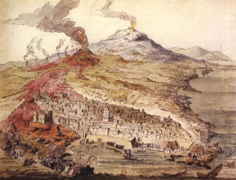
Spectacular reproduction
of a fresco in the Cathedral of Catania, showing the 1669 eruption
of Etna whose lava flow caused significant damage in Catania and destroyed
numerous villages.
This
drawing shows the main crater of the eruption near Nicolosi in vigorous
explosive eruption and the lava flows extending from it (in red color)
to Catania. In the lower left the Castello Ursino, surrounded by the
lava, is shown. Also visible, to the north of the city, is the still-barren
lava flow erupted a few centuries earlier (possibly in 1381) from
a fissure near the village of Mascalucia, which entered the sea at
Ognina, now a densely populated part of Catania. Also note the medieval
architecture of the cathedral (large tower in the lower center) which
was destroyed in the 1693 earthquake, along with large part of the
city. The Castello Ursino (seen surrounded by the 1669 lava flow in
lower left of the image) survived both the eruption and the earthquake.
The 1669 eruption
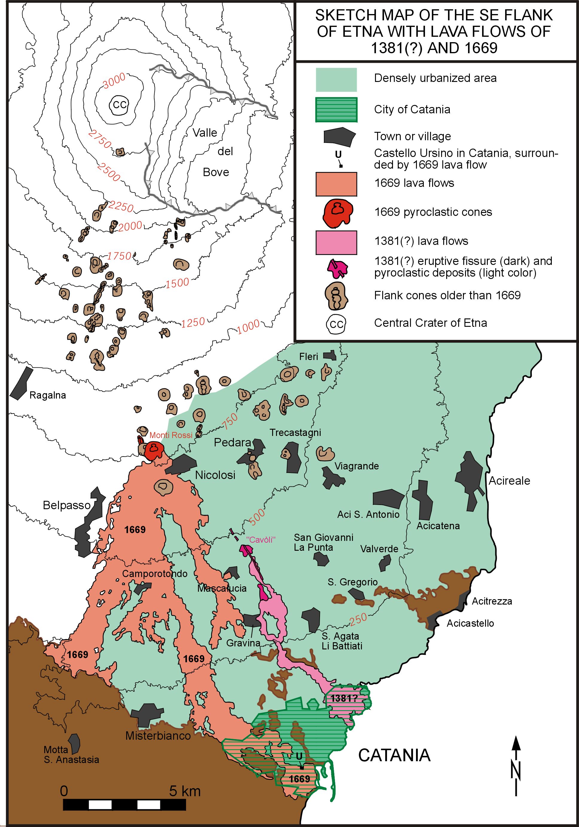
MAP OF THE SSE
FLANK OF ETNA, SHOWING LAVAS OF 1381(?) AND 1669
The
brown-colored patches in the lower left corner and near Catania and Acireale-Acicastello
(which are not labeled in the legend) correspond to the sedimentary basement
of Etna. The most recent lava flow that reached the area of Catania and
entered the sea occurred in 1669. The second most recent lava flow to
reach Catania (without damaging it) and to enter the sea to the north
of the city is usually attributed to an eruption in 1381. However, the
French volcanologist Tanguy disputes that date, because the orientation
of the paleomagnetism of the lava flow coincides with an eruption date
sometime between AD 1050-1250. More discussion of features shown in the
map is available on the Etna maps page.
The 17th century was a period of particularly intense eruptive activity at Etna. During the period from about 1600 until 1669, eight flank eruptions occurred in various sectors of the volcano, and some of them were of unusually long duration (1614-1624, 1634-1638, 1651-1653) and volume (1614-1624: about 1-2 km3; 1669: about 1 km3). The mean output rate during the period 1600-1669 was calculated by Hughes et al. (1990) at 1.19 m3 s-1, considerably higher than during any period after 1669.
The culminating and concluding event of that period was the devastating eruption of March-July 1669. This ranks among the most peculiar eruptions of Etna for the following reasons: 1) the intensity of the activity, as manifest in the large volume of eruptive products and the extremely high output rates during this four months-long event, 2) the location of the main vents at elevations of only 800-850 m, 3) the large number of detailed and quite accurate contemporaneous descriptions (unlike many descriptions published much later in text books, travel guides and the mass media), 4) the first documented attempts to divert a lava flow. The 1669 eruption is also of great significance for volcanic hazard evaluations at Etna. The eruption of 1669 was the most recent to affect Catania. The lack of similar events since then has created the (false) impression among the local population that eruptions like that of 1669 do not occur anymore.
The following description of the eruption and its effects is based essentially on three recent publications: Pagnano (1992), Corsaro et al. (1996) and Tanguy and Patanè (1996). The first and last of these works provide ample citations from contemporary accounts of the events of 1669 and are therefore considered highly accurate; furthermore Corsaro et al. presented volcanological and petrological data about this eruption which had hitherto received little attention from modern researchers. Still more recently, Crisci et al. (2003) presented the results of a simulation of the development of a lava field produced by a repetition of the 1669 eruption, underlining the significance of lava tubes for far-traveling lava flows.
CHRONOLOGY
Vigorous seismicity preceded the onset of eruptive activity
by more than two months, and earthquakes became particularly intense on
8 March 1669. The epicentral area was near Nicolosi on the S flank of
the volcano, located between 750 and 800 m elevation. While most residents
left this village, ever stronger tremors destroyed most of their homes
on 10 and early 11 March. The latest of these events appears to have been
accompanied by the opening of a 9 km-long fracture that extended from
Monte Frumento Supino (a cinder cone located about 2 km S of the summit,
at 2845 m elevation) to near Monte San Leo (at 1200 m elevation). Some
eruptive activity occurred at various, though unspecified, locations along
this fracture, with the focus of activity possibly migrating downslope.
On the afternoon of 11 March, probably at around 16 h, several vents burst open in the area between Monte Nocilla and Monte Fusara, immediately to the NW of the doomed village of Nicolosi. These vents produced incessant powerful explosions, while a huge lava flow issued from vents located somewhat further downslope - possibly even at the base of the Mompilieri cinder cone (the cone next to the south of the main 1669 cone on the map). During the next few days the continuous and strong explosive activity at the main vents began to build a large pyroclastic cone, which was initially named "Monte della Rovina" (mountain of destruction) but is now known as Monti Rossi. Meanwhile lava flowed downslope in two main branches, overwhelming hamlets, villages and towns. The remains of Nicolosi and the villages of Mompilieri and Malpasso were consumed during the first 24 hours of the eruption (the site of Mompilieri is now covered by the outskirts of Nicolosi, whereas Malpasso was reconstructed at a new site and renamed into Belpasso). During the next three days the villages of San Pietro Clarenza, Mascalucia, Camporotondo and San Giovanni Galermo vanished under the enormous river of lava that advanced rapidly and relentlessly southwards, heading for some of the major towns of the Catania region, and for the city of Catania itself. Refugees from the destroyed and threatened villages fled to Catania and were housed in public and private edifices.
One week after the start of the eruption the two main lava branches were approaching towards the major towns of Paternò and Misterbianco, burying a number of smaller villages on their paths, which were never rebuilt and whose locations are not known. The eastern of the flow branches ate through Misterbianco on 25 March before ponding in a small depression to the W of Catania (the "Gurna di Nicito"), which was possibly filled with a lake. Once the depression was filled, the lava resumed its advance, heading directly towards Catania.
On the day Misterbianco was destroyed (25 March), violent explosions occurred at the summit crater, heralding the partial collapse of the summit cone. This collapse has been the subject of some debate: various authors ascribe the Piano caldera - the youngest and smallest of the at least five calderas discovered so far on Etna - to that event, but it is now generally assumed that the caldera formed about 1800 years earlier, during the much more violent summit eruption of 122 BC. It is likely that the collapse structure occupied an area not larger than the present main summit cone. The explosions accompanying the collapse were probably phreatomagmatic, and blocks up to 15 m in diameter were ejected to a distance of 1 km from the crater, while hot scoria falls occurred up to 8 km from the summit (Tanguy and Patanè, 1996).
|
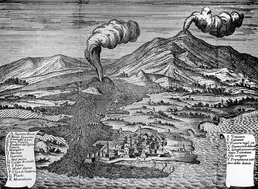
| An
old sketch showing Etna and Catania during the 1669 eruption. In
this bird's eye perspective the view is towards NNW, showing the
fuming summit of Etna in the background while an eruption column
is rising from a crater on the S flank, now called Monti Rossi,
shown in the middle ground. This crater is feeding a large lava
flow which has reached, and partly surrounded, the city of Catania,
in the foreground.
|
The eastern lava flow reached the city walls of Catania on the W side of the city in early April and was deflected southwards by the walls which initially withstood the pressure of the river of molten rock. On 23 April the lava, which had previously surrounded the Castello Ursino (a Norman fortress located at the shore on the S margin of Catania), entered the sea with a front more than 1 km wide and rapidly filled the harbor of the city. At about the same time, the level of lava accumulating against the city walls in the W of Catania gradually rose to the crest of the structure. A minor overflow of lava into the W part of the city caused little damage, but worse was yet to come. On 30 April, a section of the walls gave way to the pressure of the accumulating lava, allowing it to enter the city from the W. Two lobes of lava surrounded and partially destroyed churches, monastries and other buildings around the church of San Nicolò l'Arena. Walls were hastily built across major roads leading to the lower areas of the city in order to halt the advance of the lava in the city. Pagnano (1992), on the base of contemporary documents, describes these walls as highly functional and successful in keeping the lava from causing more widespread damage (see below). However, during June, more lava flows reached the zone of the Castello Ursino and the seaside, causing fears of a renewed destructive invasion of Catania by lava. It seems, though, that the worst was over, even though the eruption continued for another month before ending on 11 July.
ERUPTIVE
PRODUCTS AND PETROLOGY
The 1669 eruption produced between 0.5 and 1 km3
of lava and about 0.25 km3 of pyroclastics. Throughout much
of the eruption lava probably flowed through an extensive tube system,
thus covering a distance of up to 17 km from the eruptive vents. An extensive
lava field was formed, covering a surface of 37 km3. At the
end of the activity, one of Etna's largest flank pyroclastic cones towered
over a vast desert of pyroclastics where only four months before villages
and fruit gardens had flourished (even though Nicolosi had already suffered
from a local earthquake in 1633). The tephra fallout was largely dispersed
eastwards.
Petrologically, the 1669 lavas form two distinct groups (Corsaro et al., 1996) which show no evidence of continuous crystal fractionation processes from a common parent magma, the lavas erupted early in the eruption being more mafic than later, more evolved lavas. Corsaro et al. interpreted these variations as evidence for fresh mafic magma piercing through a shallow reservoir filled with more evolved magma. The fresh magma, being rich in magmatic volatiles, was more buoyant than the evolved melt and thus rose across the reservoir as a "rapidly uprising laminar plume" without mixing with the surrounding magma and retaining its original chemical characteristics. Corsaro et al. (1996) link the beginning of eruption of the more evolved lava to the explosive summit activity and collapse on 25 March which may have been a response to a pressure drop in the central conduit, following the eruption of the more volatile-rich magma of the first eruptive phase.
The 1669 eruption thoroughly affected the internal plumbing system of Etna and thus its eruptive behavior. For the next 80 years, the average output rate dropped to very low levels, and there were only three flank eruptions between 1669 and 1755 (1689, 1702, and 1755), compared to 8 in the first 70 years of the 17th century. However, historical sources indicate that near-continuous and vigorous eruptive activity occurred within the collapse crater at the summit, and thus a new summit cone began to form.
|
|
 |
| Two
recent photos of the main eruptive cone formed during the 1669 eruption,
the twin-peaked Monti Rossi near the town of Nicolosi. The name,
translated literally, means "Red Mountains" (the plural
refers to the two peaks, although the cone is one), but actually
is a local corruption of "Monti Grossi" (the Huge Mountains),
applied also to other large flank cones of Etna. The original name
of the cone, used during the period following the eruption, was
"Monte della Rovina", the Mountain of Destruction. Left photograph shows the characteristic shape of the cone as seen from north in the spring of 2000. The gap between the two peaks hosts several explosive vents that produced large amounts of tephra during the eruption. Right photograph, taken approximately one year after the left one, is a view from the western of the two peaks toward Catania. In the foreground one of the crater depressions within the cone can be seen; the background is constituted by an endless quantity of buildings that formally belong to different administrative areas but in reality form one continuum extending from Nicolosi to Catania. With that reality, no one really wishes to imagine the effects of a new eruption in the same area, and of the same magnitude, of the 1669 eruption |
|

IMPACT
ON SOCIETY AND DEFENSE MEASURES
Devastation caused by the 1669 eruption was widespread.
At least 10 villages were completely destroyed and many others severely
damaged by the lava flows and, to a lesser degree, by the tephra falls.
The W part of Catania suffered heavy damage due to the invasion by lava.
The areas to the W and SW of the city, formerly rich with fruit gardens
and various villas and several monuments of Greek and Roman time were
turned into a wasteland, and Catania was now encircled by lava flows on
all sides except on that facing the sea. To the north the city was bordered
by the still-barren flow attributed to the 1381 eruption (but possibly
this flow is up to 200 years older), and the 1669 flow formed a vast area
of desolation on the SW and W sides of the city.
However, many sources ranging from geology and geography textbooks over tourist guides to the mass media provide a false idea of the eruption and its effects. Some attribute up to 10,000 deaths to the eruption (in which case Etna would be a worse killer than Vesuvio, its much more explosive neighbor volcano near the city of Naples). Most of these sources state that Catania was completely destroyed by the lava flow (this is even reported on p. 351 of Chester et al., 1985), turned into an inferno of fire from which many did not escape. Obviously these statements result from confusing the eruption with a devastating (tectonic) earthquake that shattered most towns in SE Sicily only 24 years after the eruption and killed between about 54,000 people, including two-thirds of the population of Catania (Bianca et al., 1999).
Of Catania, only a relatively small portion was destroyed. Damage was most widespread on the W side of the Sangiuliano hill, beyond the magnificent church of San Nicolò l'Arena and the Benedictines monastery. Soon after the invasion of Catania by the lava measures were undertaken by the Vicar don Stefano Reggio to protect the low-lying areas of the city: the construction of barriers made of stone across the main streets. "The swiftness of the decisions, the smooth operation and the efficiency of the operation must be admired, considering the tools available in those times, and the dimensions of the problem, which would represent enormous difficulties even in a modern state if confronted with a similar situation" (Pagnano, 1992).
Houses next to the lava front were demolished to use the bricks for the construction of a large barrier across the Strada del Corso, the most critical location. The lava flow was in fact stopped by this obstacle, and another similar barrier was built near the church of Madonna della Palma where another flow had breached the city walls.
The success of these efforts led to another, more famous, attempt to divert the lava flow much closer to its source, in order to stop supply to the active lava fronts in the Catania area. This attempt, carried out by a group of people led by don Diego Pappalardo from Pedara, aimed at rupturing the roof of the lava tube (or the lateral levee of the main flow channel). In this manner the lava should be forced to chill rapidly outside the protective tube or channel. It is often mentioned that after the success of their effort, armed men from Paternò arrived on the scene, because the new artificial flow threatened their town, and forced Pappalardo and his men to abandon the diversion site. As a consequence the lava flow reportedly reoccupied the old tube system (or flow channel), and lava again flowed towards Catania. However, the clash between the Paternesi and Pappalardo's men is not mentioned in Pagnano (1992).
In any case the series of protective measures carried out in Catania and near the eruptive vents appear to have been largely successful. As a result of the oft-quoted discrepancies between the inhabitants of Paternò and those of Catania during the latest diversion effort, any artificial lava flow diversion was forbidden by law in Italy - until 1983.
References
Corsaro RA, Cristofolini R, Patanè L (1996) The 1669 eruption at Mount Etna: Chronology, petrology and geochemistry, with inference on magma sources and ascent mechanisms. Bulletin of Volcanology 58: 348-358
Crisci GM, Di Gregorio S, Rongo R, Scarpelli M, Spataro W, Calvari S (2003) Revisiting the 1669 Etnean eruptive crisis using a cellular automata model and implications for volcanic hazard in the Catania area. Journal of Volcanology and Geothermal Research 123: 211-230
Pagnano G (1992) Il disegno delle difese. L'eruzione del 1669 e il riassetto delle fortificazioni di Catania. C.U.E.C.M. Catania, 1-224
Tanguy J-C, Patanè
G (1996) L'Etna et le monde des volcans. Diderot
Editeur Paris: 1-279
Copyright © Boris Behncke, "Italy's Volcanoes: The Cradle of Volcanology"