
| Etna
index |
||
| Geology | Geological history | Cones and craters |
| Eruptive characteristics | Eruptions before 1971 | Eruptions since 1971 |
| Etna and Man | References | Web sites |
| Weather forecasts | FAQ | Latest news |
The 1928 eruption
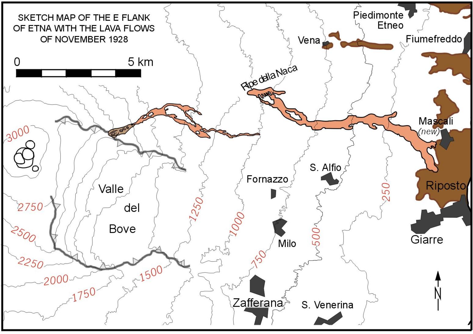
MAP OF THE 1928
LAVA FLOWS (ATTENTION: 200 k jpg)
The
1928 lava is shown in pink color. Note that the brown-colored patches
in the right part of the map correspond to the sedimentary basement of
Etna.
The most destructive Etnean eruption during the 20th century occurred in November 1928 and led to the destruction of the small town of Mascali (pronounced Màs-ca-li). This was actually the first time since 1669 that an entire population center was destroyed by an eruption of Etna, and no similar destruction has been caused by any eruption at this volcano since then (as of early 2002). While the course of the events was similar to that of other eruptions during this century (the progressive downslope propagation of eruptive fissures), the eruption was unusual because the most productive vents formed at low altitude (down to 1150 m elevation) in an area of infrequent eruptive activity. A rough timetable of the course of events is given below (green box). For more information (in Italian language) and photos go to the web site of the town of Mascali (unfortunately as of early 2002 the site is offline). You can see a selection of newspaper articles, a photo album with numerous b/w images and video clips(!), and information on the rebuilt town - and yes, you will also find a link back to this page!
The eruption began on the afternoon of 2 November with strong activity in the summit area, then a system of eruptive fractures began to propagate down the ENE flank, leading to the opening of eruptive vents at three sites. Each time the opening of a new fracture segment was preceded by the cessation of activity at the one formed previously. On the evening of 4 November the lowermost fissure opened in a forested area known as "Ripe della Naca", close to a tectonic fault, and lava began to issue at a high rate to form spectacular cascades on the fault scarp before it began to descend along a ravine named Torrente Pietrafucile. The town of Mascali lay at the downslope end of this ravine, and it took the lava flow little more than two days to obliterate any trace of it.
|
The eruption |
| Date | Hour | Remarks |
| 2 November | 1630 | Strong explosive activity at NE Crater (plumes to 1 km high), then ash puffs every minute until 1800. No glow visible at dusk, and no activity at Central Crater |
| 1805 | A fissure
opens in the Valle del Leone with strong explosive activity, and
lava fountains about 200 m high are well visible both from Catania
and Taormina. This activity is accompanied by loud detonations and
strong ash emission. This fissure is about 150 m long and emits several small lava lobes (not displayed on the map above) up to 500 m long and about 200 m wide |
|
| 1820 | Activity at the Valle del Leone fissure diminishes, and shortly afterwards the glow visible at this site fades | |
|
quiet
until early next day
|
||
| 3 November | 0330 | New vents open at Serra delle Concazze (2500-1900 m elevation), and voluminous lava emission occurs from the lower part of the fissure. The main lava flow threatens the village of Sant'Alfio |
| ~1500 | Ash emissions resume at NE Crater, followed by ejections of blocks and lapilli | |
| 1630 | The lava flow from the Serra delle Concazze vents continues, but at diminishing rate | |
| 4 November | 0400 | New fractures and a graben form between 1900 and 1550 m elevation, across the Piano delle Donne and Ripa di Piscio, but little eruptive activity occurs here |
| 0830 | Minor effusive activity continues from the Serra delle Concazze vents | |
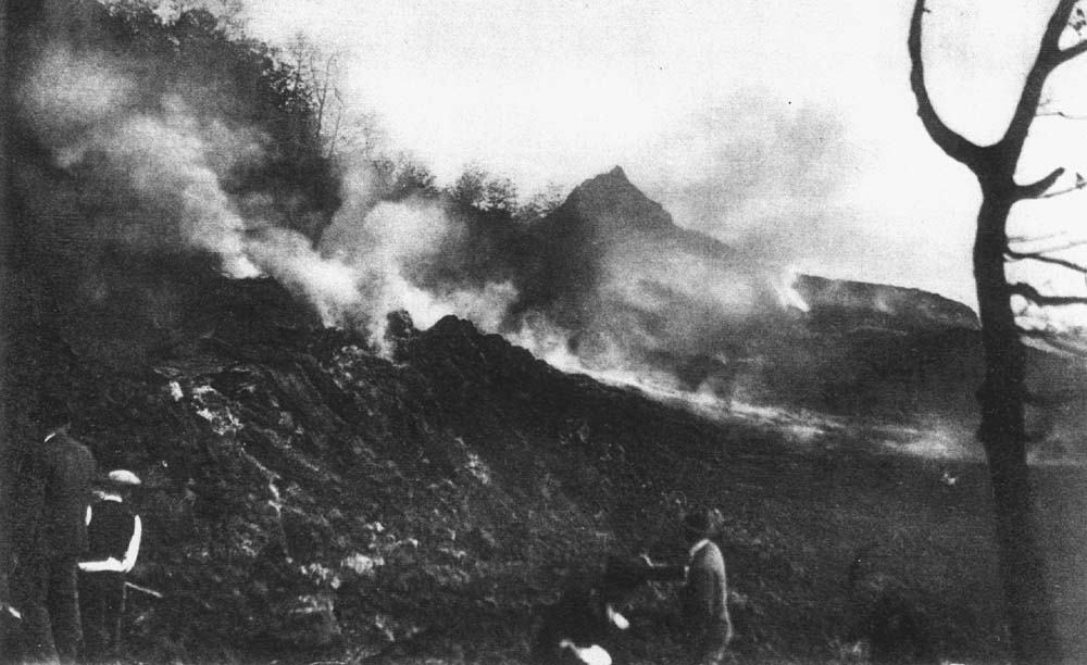
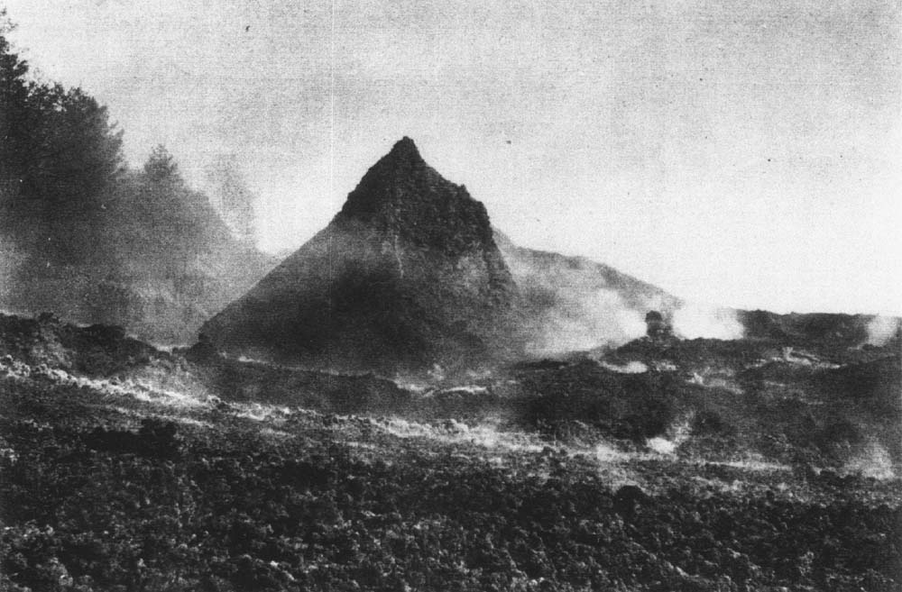
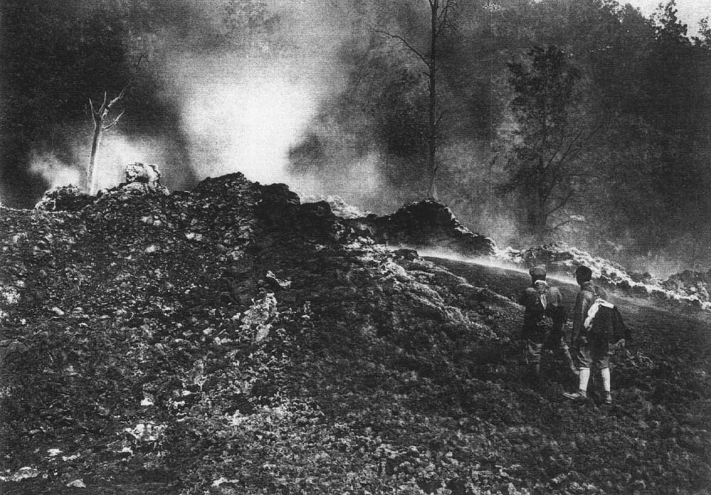
| ~2100 | Another eruptive fissure with numerous effusive vents opens at Ripe della Naca (1200-1150 m elevation), and very fluid lava rapidly cascades down the fault scarp to advance along the bed of Torrente Pietrafucile. See the photos 1-5 at left | |
| night of 4-5 November | The lava flow advances rapidly, burying the small villages of Pietrafucile and Costa Sovara. | |
| 5 November | evening | The flow front is near the Circumetnea railway and moves at a speed of 200-300 m per hour. The evacuation of Mascali (about 2000 inhabitants) is ordered. The lava now threatens the Circumetnea and the State railway lines, power lines and telecommunication lines. At the Ripe della Naca vents, several spatter cones and hornitos grow thanks to mild explosive activity |
| 6 November | day | The main lava flow now is heading for Mascali. At 0700 it reaches and cuts the Circumetnea railway, a few hours later it interrupts the road Piedimonte-Nunziata |
| 1845 | The flow reaches the first house of Mascali and then proceeds on its relentless path all the way across the town. The water supply to Riposto is interrupted | |
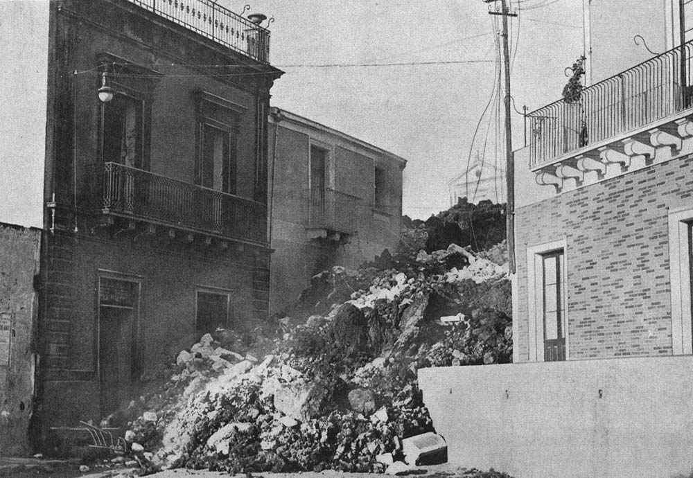
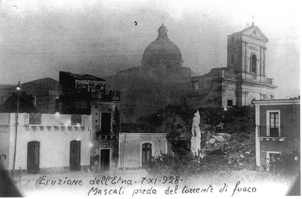
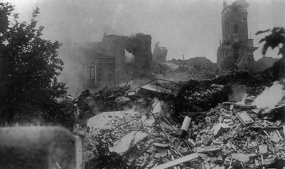
| night | Besides Mascali, the lava also consumes several houses of the nearby village of Nunziata. Near 2230, the lava reaches the church of Mascali whose tower, however, remains standing until the next morning (photos 5 and 7 at left) | |
| 7 November | morning | At daybreak, destruction of Mascali is close to complete. The flow front, 300-400 m wide, continues to advance, though at decreasing speed. Its distance from the source vents is now more than 7 km. A branch of lava menaces the village of Carabba, southeast of Mascali |
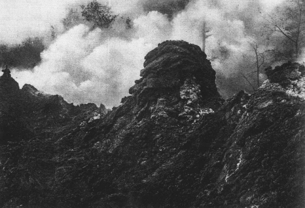
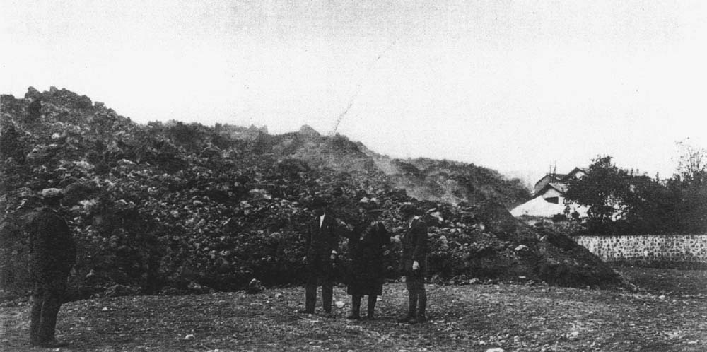
| 8 November | The flow front advances very slowly but broadens, thus consuming precious fruit gardens, vineyards and other cultivated land (photo 6 at left). It slowly advances toward the State Railway line, the most important communication line in eastern Sicily | |
| 9 November | The lava flow front continues to advance slowly, and by 1600 it is only 75 m from the State railroad | |
| 10 November | 0110 | The lava front arrives at the State Railway line and overwhelms it, interrupting it over a length of 500 m and consuming also the station of Mascali |
| 11 November | Although advancing only a few meters per hour, the lava consumes a few houses of Carrabba | |
| 12-18 November | Lava continues to flow from the Ripe della Naca vents, but the flow front has practically ceased moving. On 16 November the flow front stops at 25-30 m elevation | |
| 19-20 November | Ash emissions from Central Crater and NE Crater up to 1.5 km high. Lava emission from the Ripe della Naca vents ends on 20 November | |
The 1928 eruption produced
about 40 million cubic meters of lava, much less than is written in many
sources, and thus was not a particularly large eruption for Etna standards.
The destructive potential came from two other important factors: the low
elevation of the main eruptive vents (1150 m) and the high effusion rates
during the first days of the activity, which may have exceeded 100 cubic
meters per second. In comparison, the peak effusion rates during the July-August
2001 eruption were less than 20 cubic meters per second. For these reasons
the lava flow that brought the destruction of Mascali advanced very fast
along a narrow valley. The unfortunate town was located at the valley
floor, which is probably the worst place for a town to lie near an active
volcano.
Many sources attribute the death of up to 5 people to the 1928 eruption, including "an elderly couple" that was overwhelmed by the lava while sleeping. Recent research by Duncan et al. (1996) and Chester et al. (1999) shows that instead, the eruption did not cause any fatalities, because Mascali was completely and orderly evacuated in time and residents not only had the time to save their lives and their households, but movies filmed during the eruption show people removing the rooftiles from their homes before these were engulfed by the lava.
The 1928 eruption occurred at the height of the fascism era, under the totalitarian leadership of Mussolini. Mussolini's government saw in the destruction of a small town a good opportunity to demonstrate its efficiency in providing aid and rapid rebuilding of the town in a new site. As a matter of fact the "new" Mascali offered a completely different standard of life to the displaced inhabitants of the destroyed town. Compared to most other towns and villages around Etna, the rebuilt Mascali appears much more modern, and it contains a number of public buildings of a peculiar architectural style that is characteristic of the Mussolini era. Most impressive is the main church ("chiesa madre"), which is ornamented with a large torch, symbol of the Italian fascism, standing above the statue of Christ. The publications by Duncan et al. (1996) and Chester et al. (1999) on this subject are an entertaining read.
REFERENCES
Chester DK, Duncan AM, Dibben C, Guest JE and Liste PH (1999) Mascali, Mount Etna region, Sicily: An example of Fascist planning during the 1928 eruption and its continuing legacy. Natural Hazards 19: 29-46.
Duncan AM, Dibben C, Chester DK and Guest JE (1996) The 1928 eruption of Mount Etna volcano, Sicily, and the destruction of the town of Mascali. Disasters 20: 1-20.
Friedlaender I (1929) Der Ätna-Ausbruch 1928. Zeitschrift für Vulkanologie 12: 33-46.
Imbò G (1933) Osservazioni e ricerche in relazione all'eruzione etnea 2-20 novembre 1928. Bulletin Volcanologique ser I, 5 (1928): 120-176.
Copyright © Boris Behncke, "Italy's Volcanoes: The Cradle of Volcanology"