![]()

| Stromboli
home page |
||
| Geography | Geological Evolution | Eruptive history |
| Volcanic Hazards | References | Web sites |
Geological evolution of Stromboli
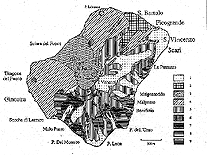 Geological sketch map of Stromboli island, from Hornig-Kjarsgaard et al. (1993). Click on thumbnail to view large version and legend. |
||
|
|
 Geologically the oldest part of the Stromboli volcanic system, the "neck" of Strombolicchio (a remnant of a volcanic conduit) rises from the sea about 1.5 km NE of Stromboli (in the background). In this photograph, taken on the early morning of 29 March 1990, a dense volcanic gas plume is being carried down to the village of Stromboli, causing a slight smell of sulfur even beyond Strombolicchio. |
||
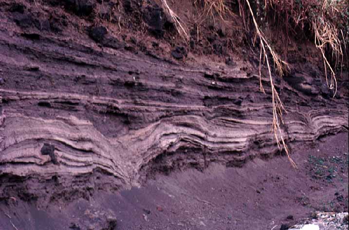 Beds of phreatomagmatic deposits rich in accretionary lapilli. This outcrop, photographed in September 1989, has meanwhile disappeared since it lies in an area now in private property. Its location is between the two main fractions of Stromboli village, San Vincenzo and San Bartolo. The deposits may be correlated with violent explosive volcanism associated with the sector collapse at Stromboli that left the Sciara depression about 5000 years ago. |
||
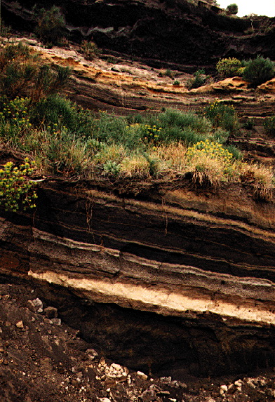 Traces of a violent past: this outcrop at the W coast of Stromboli cuts through scoria and lapilli fall deposits of the Scari formation (Hornig-Kjarsgaard et al., 1993). The prominent light-colored horizon is a distal tephra deposit erupted on the island of Ischia, between 40 and 60 ka ago. |
||
|
|
In the stratigraphy of Hornig-Kjarsgaard et al. (1993) and on the geological map of Stromboli by Keller et al. (1993), the following volcanostratigraphic units are identified:
- Strombolicchio
- 1) Strombolicchio eroded volcanic neck
- Paleostromboli
- 2) Lower Paleostromboli (PST) I lavas
- 3) PST I Pyroclastic Series
- 4) Upper PST I lavas
- 5) Lower Rina lavas
- 6) Omo lavas
- 7) Vallone Rina-Malo Passo Pyroclastics
- 8) Middle Vallone di Rina lavas
- 9) Upper Rina Lavas
- 10) Aghiastro lavas and pyroclastics
- 11) Cavono pyroclastics
- 12) Diatreme vent of Malo Passo
- Vancori and Scari
- 13) Lower Scari Tuffs (LST)
- 14) Scari Lava
- 15) Upper Scari Tuffs (UST)
- 15a) Lower Vancori and Middle Vancori Pyroclastics
- 16a, b) Lower Vancori (Lower Vancori-a) and Frontone lavas (Lower Vancori-b)
- 17) Middle Vancori lavas
- 18) Upper Vancori breccias
- 19) Upper Vancori lavas
- 20) Frontone breccias
- 21) Roisa scoriae and lavas
- Neostromboli
- 22) Neostromboli lavas
- 23) Timpone del Fuoco lavas
- 24) Labronzo lavas
- 25) Nel-Cannestrà lavas
- 26) Lazzaro pyroclastics
- Recent Stromboli
- San Bartolo lavas
- Pizzo sopra la Fossa pyroclastics
- Sub-recent Sciara lavas
- Recent Sciara activity
- Epiclastic volcanic materials
A fine, well-designed series of pages showing the geological evolution of Stromboli is available at Stromboli On-line.
.
Copyright © Boris Behncke, "Italy's Volcanoes: The Cradle of Volcanology"
Page
set up in late 1995, last modified on 12 February 2000