
| Vesuvio
index |
||
| Eruptive history | Volcanic hazards | References |
| Eruptive characteristics | Geophysical monitoring | Web sites |
| Latest news |
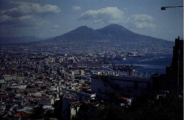
Vesuvio looming above the densely populated area of Napoli (1992)
Vesuvio (Vesuvius) Volcano, Italy
volcano number: 0101-02= (according to Volcanoes of the World, 1994 edition)
summit elevation: 1281 m
location: 40.821°N, 14.426°E
![]()
"Among Earth's volcanoes, Vesuvio not only has
a peculiar geological history, but its history is also intimately interwoven
with the history of humanity".
Translated from
Richter (1986)
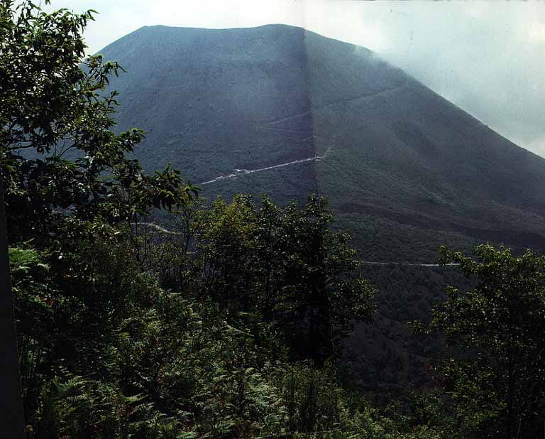 The historically active cone of Vesuvio, seen from the crest of Monte Somma, September 1989. The road carrying up to 1000 m elevation and the footpath leading from there to the summit are discernible. |
|
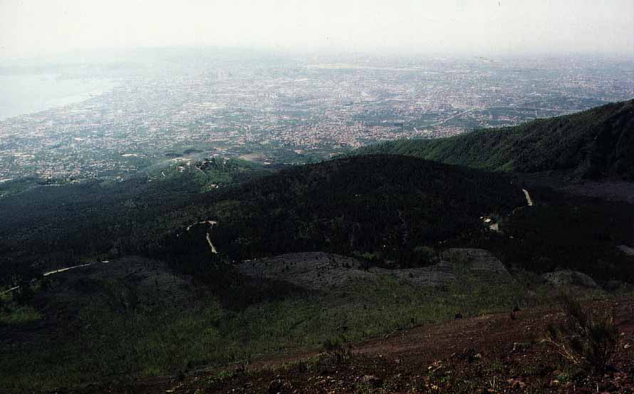 View from the northwestern crater rim of Vesuvio over the lava shield Colle Umberto (formed in 1895-1899) and 1944 lava flows (gray areas in the right part of the image and in front of Colle Umberto) towards the densely populated areas between the volcano and the volcanic complex of Campi Flegrei (the hills visible inleft background), including the city of Napoli. The photo was taken on 18 May 1996. |
|
Certainly the most notable aspect of Vesuvio's eminence among Earth's volcanoes is the dense population surrounding it and climbing higher and higher up its slopes (the map above only shows the locations of towns' centers but not their present extent). Half a million people live in a near-continuous belt of towns and villages around the volcano, in the zone immediately threatened by future eruptions. The situation is still more peculiar as Vesuvio is not the only volcano looming above that area and its people - there is, on the other side of the city of Napoli (Naples), the caldera of Campi Flegrei, renowned for some cataclysmic ash-flow forming eruptions in the all-too-recent geologic past and signs of unrest during the past three decades. There is also the historically active volcanic complex of Ischia, not threatening to Vesuvio inhabitants but to those on Ischia island itself. To complete this ensemble of geologic hazards, the area forms the nucleus of a much vaster zone that is seismically vulnerable; its most recent disastrous earthquake, on 23 November 1980, killed more than 3,000 people.
Amidst an enchanting landscape with beautiful islands, magnificent mountain ranges, marvellous coasts and historically famed cities, Vesuvio is the focal point, lying in the center of a plain on the ENE side of the Gulf of Napoli. It is the steepness, the abrupt way it rises from its placid surroundings, that render it so impressive. It is the imagination of how that thing must have looked like when it was erupting and how it must have been to those living close to it that give it such a feel of power.
An unusual view
of Vesuvio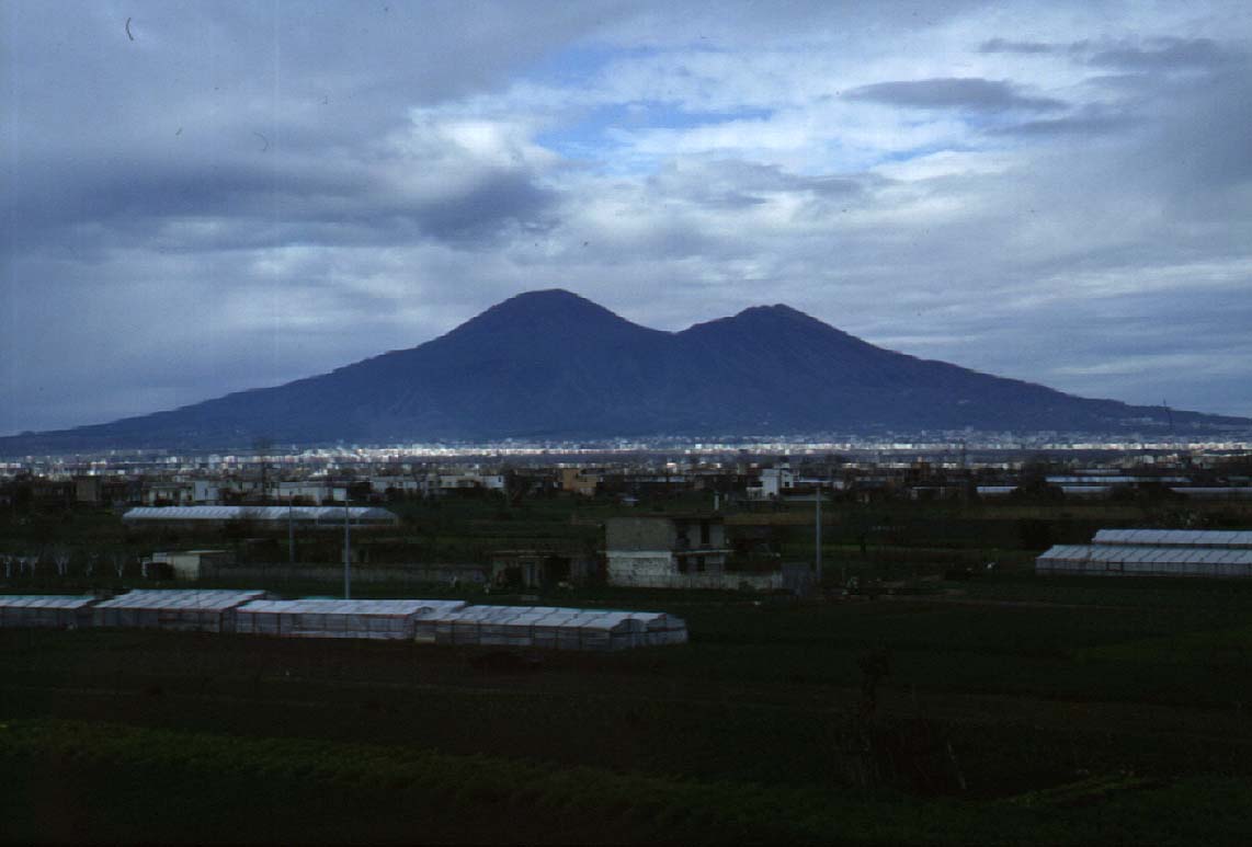 Something look strange in this photo? No, it's not inverse, but this is the very unfamiliar view of Vesuvio from east - taken on 16 February 1997. |
|
Aerial views of
Vesuvio Vesuvio seen from NW, early 1990's. The 1944 lava flows and hot avalanche deposits are still well discernible (due to lack of significant vegetation). Monte Somma is to the left. In the foreground, at bottom of image, a cluster of buildings is visible, this is the Osservatorio Vesuviano and neighboring tourist facilities. The densely forested Colle Umberto, a lava shield formed in 1895-1899, looms above the buildings. 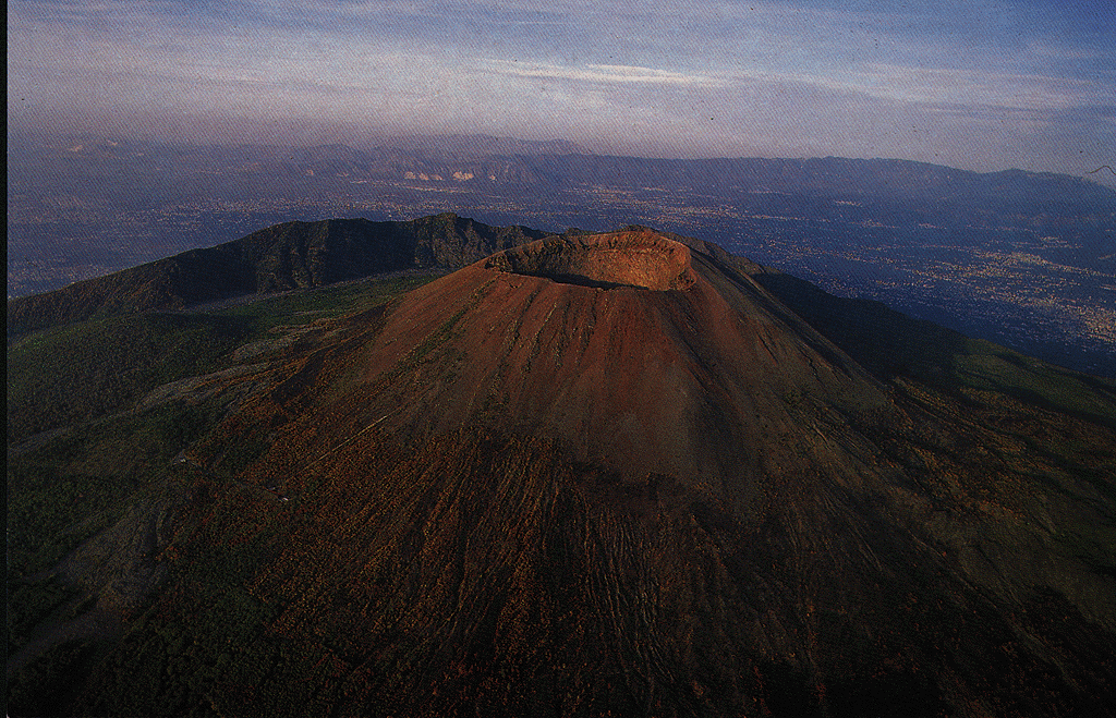 Vesuvio from the air, probably in 1995. View is towards NNE. Note vegetation on the cone and towns in the background. Vegetation is even beginning to conquer the crater itself: there are small trees growing within the impressive pit and on the rim there is a (still discontinuous) cover of grass. |
|
| Photos
copyright Editore Vincenzo Carcavallo, Napoli
|
The last eruption thus far was in 1944. Since then, the population in the immediate surroundings has had a manyfold increase. Take the bus up to the "quota mille" (the terminus at 1000 m elevation on the historically active cone) from Ercolano or Torre del Greco, and for the first 25 minutes, you don't get out of the sea of houses. Upwards, the homes get more and more luxurious, accompanied by tens and more tens of hotels and pensioni. After being stricken by the massive way the volcano dominates that area, the second surprise is how green it is. Reforestation has been carried out vigorously in the 50+ years since the most recent eruption. Even the lava flow of 1944 on the caldera floor of Atrio del Cavallo, still barren in most places and still a distinct reminder of the volcano's potential, carries small trees that have appeared only during the past few years. Small trees are even beginning to grow within the crater, and parts of the crater rim have a cover of green grass.
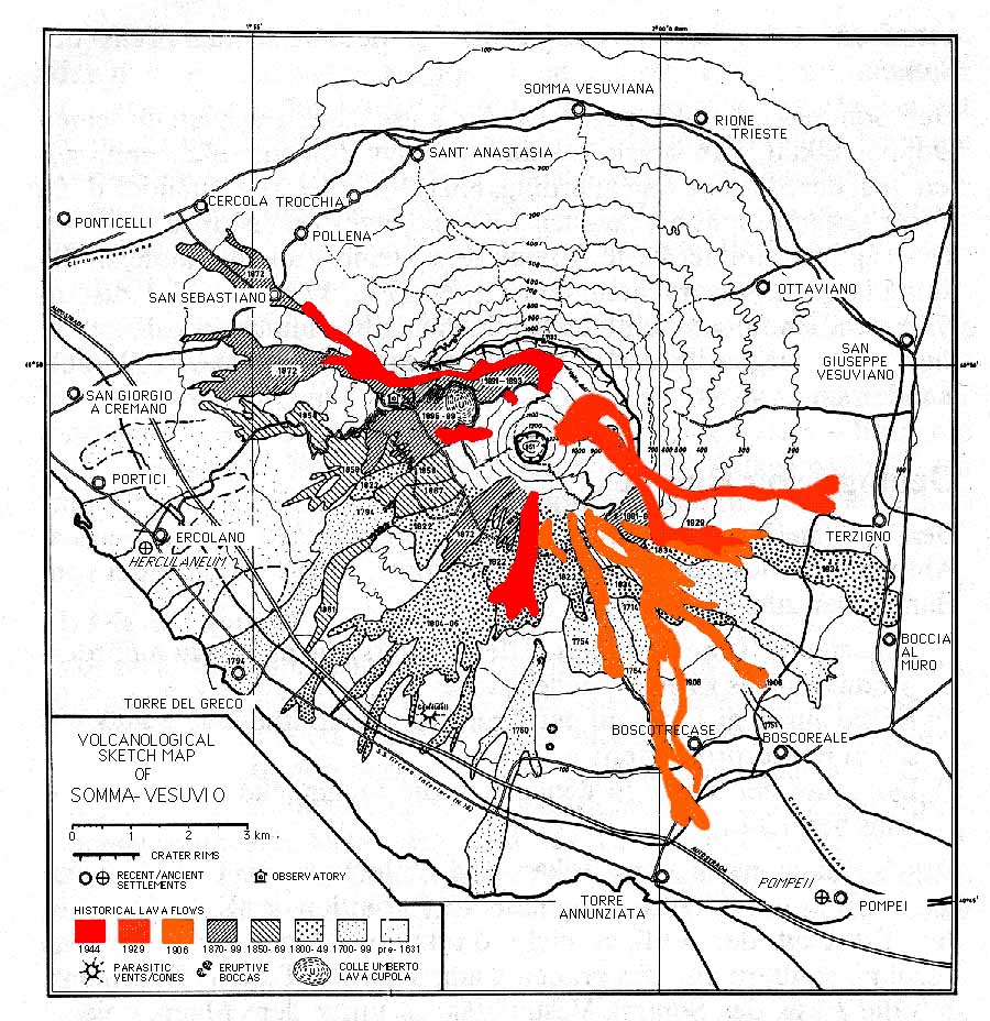 Overview map of Vesuvio, showing historical lava flows, locations of towns, roads, and railways. 20th century lava flows are outlined in color. This map was modified from Pichler (1970); modifications include deletion of excursion sites and change from "1631 lava" to "pre-1631 lava". |
|
|
|
Three types of eruption are generally distinguished in the modern literature: a) Plinian (AD 79, Pompeii type) events with widespread airfall and major pyroclastic surges and flows; b) sub-Plinian to Plinian, more moderately sized eruptions (AD 472, 1631) with heavy tephra falls around the volcano and pyroclastic flows and surges; c) small to medium-sized, Strombolian to Vulcanian eruptions (numerous events during the 1631-1944 cycle, such as 1906 and 1944) with local heavy tephra falls and major lava flows and small pyroclastic avalanches restricted to the active cone itself. To these three types there should be added a fourth one, though it is of the smallest dimensions of all eruption types observed at Vesuvio. It is the persistent Strombolian to Hawaiian style eruption that characterizes almost all of an eruptive sub-cycle (see below), such as was the case during the period 1913-1944. Activity of this kind is mainly restricted to the central crater where one or more intracrateral cones form, and to the flanks of the cone. Lava flows from the summit crater or from subterminal vents may extend beyond the cone's base. A somewhat particular kind of persistent activity is the slow effusion of large volumes of lava from subterminal fractures to form thick piles of lava with little lateral extension, such as the lava cupola of Colle Umberto, formed in 1895-1899.
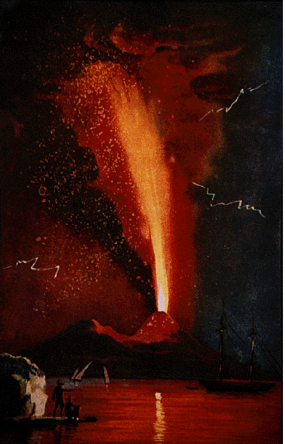 Vesuvio in eruption, August 1779. This eruption was a typical subcycle-closing event, characterized by the ejection of spectacular lava fountains rising several km above the summit, and devastating tephra falls in the northeast sector of the volcano. Image was taken from Alfano and Friedlaender 1928 (see references; bottom of this page). |
|
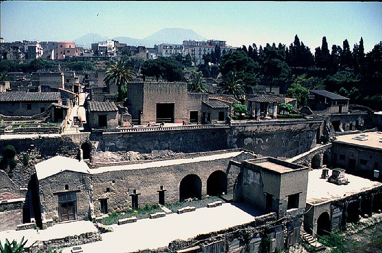 View of the excavations at Herculaneum, on the W base of Vesuvio that is barely discernible in the background. The view is from the former shoreline, now buried below at least 20 m of pyroclastic surge and flow deposits (not mudflows, as still reported in many sources). The nearest buildings overlooking the former coastline, below, are the boat chambers where hundreds of people were overwhelmed by surges and pyroclastic flows in the culminating stage of the AD 79 eruption. The ancient town lies below its modern (and much less scenic) successor, Ercolano, a fact that makes the extension of the excavations almost impossible. The photo was taken on 18 May 1996. |
|
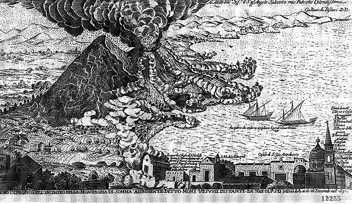 View of the 1631 eruption, showing distinct trails of "smoke" on the flanks of Vesuvio, evidence for the occurrence of pyroclastic flows. This is how Giovan Batista Passaro saw the eruption on 16 December 1631 from Napoli. Note that fallout from the eruption column is indicated on its left side, showering tephra on Monte Somma and the villages lying on its N and NE sides. This is the typical main direction of tephra fallout during eruptions of Vesuvio. Some strange pattern on the slope of Monte Somma may indicate slides of abundantly fallen tephra. |
|
Eruptive activity of Vesuvio obviously occurs in cycles that last several centuries and alternate with repose periods lasting several centuries as well. Each of these repose periods ends with a major (Plinian) eruption, thus initiating an active cycle. One of the countless problems researchers of Vesuvio have to deal with is that cycles apparently do not always repeat the same patterns and phenomena. Thus, the cycle or cycles following the 79 A.D. eruption seem to have been quite different from the most recent one, lasting from 1631 until 1944 (see the pages "Eruptions from A.D. 79 until 1631" and "The 1631-1944 eruptive cycle".
The most recent Plinian eruption of major dimensions was that of August 79 A.D. which is described on the AD 79 eruption page. It is world-famous for the destruction of the Roman towns of Pompeii and Herculaneum, a drama that has inspired the phantasy of generations of poets, philosophers and scientists.
Two more very strong eruptions have occurred since AD 79, a very poorly known one in AD 472 and another one in December 1631, which has been described in countless contemporaneous sources. Surprisingly, this event has only during the past few years been reviewed in the light of modern volcanological knowledge. It is still a matter of debate whether this eruption has been purely explosive or mixed explosive-effusive. There is no doubt that it was the most devastating eruption of Vesuvio except the AD 79 one. Numerous villages and towns were devastated by pyroclastic flows, tephra falls and lahars, and at least 3000 people died. A more detailed description is available on the 1631 eruption page.
Within an active cycle, smaller subcycles can be observed, starting with minor intracrateral (effusive and Strombolian) activity with some fluctuations until a strong eruption produces tall eruption columns, more voluminous, rapidly moving lava flows, and heavy tephra falls. This culminating, subcycle-ending eruption is followed by a brief (max. 7 years during the most recent, and well-documented, cycle, 1631-1944) repose, then intracrateral activity starts again.
Typical eruptions closing Vesuvian subcycles were those of 1767, 1779, 1794, 1822, 1872, 1906, and 1944. Each of them caused considerable damage in the towns around the volcano making all of them suffer partial or total destruction at least once during the 1631-1944 cycle. Torre del Greco, on the coast west of Vesuvio, was destroyed or severely damaged three times in that period. Lava flows entered inhabited areas also during some more intense activity in the course of a subcycle, most recently in 1929. Eruptions of this type have been seriously disruptive for life near Vesuvio in the past and would be extremely disturbing, were they to occur today. To cite one example: the 1906 eruption caused heavy tephra falls in the northeastern sector of Vesuvio, causing the collapse of almost all roofs in the towns of that area. Up to 500 people were killed in that event. 26 Peope died much the same way during the most recent eruption in 1944.
After that event, the volcano has most obviously entered one of the longer periods of repose that is maybe to last much longer - up to several centuries - until a new eruptive cycle will begin with a major explosive eruption.
Such paroxysmal eruptions produce heavy tephra falls, pyroclastic flows, surges, and lahars. Lava flows seem to be uncommon during these events. As the next eruption will probably be a paroxysmal one, primary volcanic hazards are tephra falls and pyroclastic flows and surges. They form a significant threat for a zone including parts of Napoli and the entire belt of towns around the volcano. It is likely that certain phenomena, such as increasing seismicity, deformation, and others, will warn of an impending eruption, as has evidently been the case before the AD 79 and 1631 eruptions. There are, however, serious logistical problems regarding the evacuation of maybe up to a million people in the areas endangered by tephra fall and pyroclastic flows and surges.
For a more detailed discussion of the volcanic hazards and mitigation efforts in the Vesuvian area, see the Volcanic hazards page.
Acknowledgments
The Vesuvio pages of this site have benefited from contributions from
many persons. Among them, Benedetto de Vivo (University of Napoli), Francesca
Bianco (Osservatorio Vesuviano) and Roberto Scandone (Università
di Roma Tre) merit special thanks.
The information presented here is summarized from the work of many scientists
that has led to a much better understanding of the volcano and its dynamics
in recent years. These people should be acknowledged in the first place,
and they are extensively cited in the Vesuvio bibliography and links to
other Vesuvio-related web sites.
Mike Dolan of MTU helped launch the Vesuvio web page back in early 1996
and has been a faithful assistant whenver there have been logistical and/or
technical problems with server maintenance.
since 1 July 1996.
Copyright © Boris Behncke, "Italy's Volcanoes: The Cradle of Volcanology"