![]()

| Stromboli
home page |
||
| Geography | Geological Evolution | Eruptive history |
| Volcanic Hazards | References | Web sites |
Location and geography of Stromboli
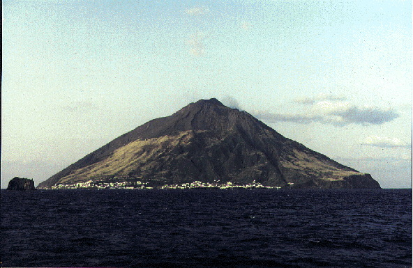 Stromboli island seen from N, with the rock of Strombolicchio at left, during approach with the ferry coming from Naples, March 1992. The peak visible here is Pizzo sopra la Fossa, which is not the highest point of the volcano, but the highest summit (named I Vancori) is hidden behind it. The active craters lie about 100 m below the Pizzo sopra la Fossa to the right and are seen here in quiet degassing activity. The main village of Stromboli, an agglomerate of two fractions (San Vincenzo and San Bartolo) extends along the NW and N coast of the island. |
|
 The relative position of the Pizzo sopra la Fossa (peak at left) and the active craters (mound visible at lower right) is well shown in this photo taken during the ascent to the summit of Stromboli on 10 March 1994. Vertical distance between Pizzo and the craters is about 100 m. |
|
|
|
The island has an area of 12.6 km2, most of which is made of the volcano itself, with two relatively gently sloping plains on which settlements have been established. The larger of these is usually called Stromboli but in fact is a conglomerate of two communities, San Bartolo and San Vincenzo. Even smaller parts of the village have their own names like Ficogrande, Piscità, etc... The village extends from the northern part of the island to its northeastern tip. Stromboli village has about 350-400 inhabitants while Ginostra, on the SW side of the island, has only about 30, and there have been articles in the local press recently, reporting the imminent total abandonation of that place. Ginostra boasts of having the smallest harbor in the world, allowing only the landing of small fishing boats while ferry ships and hydrofoils are forced to anchor about 200-300 m from the coast, and passengers are brought from or to Ginostra in a small wooden boat.
The population of the island is now only a fraction of what it was about 100 years ago. By 1910 the "Stromboliani" numbered almost 2500, but following two powerful eruptions that caused widespread damage and several casualties, many left the island, so that the number of residents dropped to only about 1200 in 1931, twenty years later there were about 660 people living on the island, and in 1971 there were only 380 left. Besides the volcanic threat, the main reason for this emigration was the low standard of life on the island, a situation which was the same on the other Aeolian islands. While some simply moved to the Italian mainland or Sicily, many others emigrated to Australia, Canada or the USA.
Since the early 1950s there has been a progressive increase in the number of visitors coming to the island. The first surge of tourism was undoubtedly a result of the worldwide fame of the movie "Stromboli, God's land" (directed by Roberto Rossellini and starring Ingrid Bergman), but during the late-1960s and early 1970s the island attracted many hippies, followed by the most recent, and most significant, invasion by tourists which is still continuing at ever increasing rate. Many of the homes abandoned by their original residents have been bought by Germans and residents of other central European countries. Many tourists solely come to see the volcano. They arrive during the day, climb to the summit, then return to the village or stay on the summit (which is dangerous and officially forbidden), and leave the island on the next morning.
 This simple sketch shows an aerial perspective of Stromboli island as if seen from N. The most salient morphological features are highlighted. |
|
|
|
The summit area of the volcano is much more complex than the view of the island from some distance would suggest. It is made up of two prominent crescent-shaped sub-concentric crests, of which the outer and higher one (924 or 926 m) is named Serra I Vancori, while the inner one culminates in a small (man-made) platform known as Pizzo sopra la Fossa (918 m) - the peak above the crater (on the topographic maps of the Istituto Geografico Militare it is indicated as "Pizzo o Sopra la Fossa" which is probably not a typing error, but has to be translated as "The Peak or Above the Crater", both denoting alternative names of the locality). Both crests are the remainders of older volcanic edifices that underwent sector collapse and were consequently partly filled by younger edifices. Erosion has carved deep ravines into the outer slopes of these older edifices, and a broad slope covered with ash from the recent activity extends from the summit area to the sea on the SE side of the island.
The arcuate depression that lies between Pizzo sopra la Fossa and the Vancori is known as the "Fossetta" in its westernmost part, while towards NE its name changes to Piano delle Croci (named after the frequent occurrence of crossed pyroxene crystals).
The active craters do not lie, as one would suspect, at the summit (even though from a distance the volcano has the characteristically truncated form of a classical stratovolcano with a summit crater), but they lie some 100-150 m below Pizzo sopra la Fossa in a large horseshoe-shaped depression open to the northwest. This depression formed by the collapse of a portion of the volcanic edifice maybe only 5000 years ago. The post-collapse activity built a new volcanic edifice within that depression, similar to the recent cone of Vesuvio that grew within the Somma caldera. However, no conspicuous central cone has formed at Stromboli, but the feature filling the collapse depression rather consists of a large talus scree, named Sciara del Fuoco, that has the active craters at its upper end. "Sciara del Fuoco" probably means something like the "fire street"; the most common explanation holds that "sciara" derives from the arabian word "Shari'a" (street) (Pichler 1981). An origin from the Italian word "sciare" (go skiing) seems unlikely (M Riuscetti, personal communication, 1995). At Etna, "sciara" is commonly used for recent to poorly vegetated lava flows.
 One of the first detailed maps of Stromboli was provided by Anderson (1905). It shows the location of the island relative to the surrounding Calabrian and Sicilian coasts and the other Aeolian Islands. The morphology of the island is shown in much detail, and the inset at lower right highlights the configuration of the crater area and the Sciara del Fuoco after the major 1891 eruption. |
|
|
|
The Sciara depression is bounded by two conspicious cliffs, or scarps, the northeastern one being called "Filo del Fuoco" while the southern one is called "Filo di Baraona". Both form immense natural barriers protecting the outer slopes of the volcano (beyond the Sciara depression) from lava flows and smaller pyroclastic flows as well as avalanches of material ejected from the craters. Filling of the Sciara depression proceeds very slowly due to the relatively low eruption rates at the active craters, and thousands of years may pass until the products of the ongoing activity will begin to spill over the confining Filo del Fuoco and Filo di Baraona.
There are three craters presently at what is commonly called the "crater terrace", a feature constatly changing and gradually growing upwards. Its longitudinal extension runs approximately NE-SW, but the craters are somewhat aligned in an en-echelon pattern. Until the mid-20th century, the crater terrace was bounded on its NE and SW ends by two conspicuous, spine-shaped rocky promontories. Numerous various names have been used to denote these features. The most commonly used names are "Filo dello Zolfo" for the one in the northeast, and "Torrione" for the southwestern one. Use of these names has been so confusing in the literature that I cited the "Torrione" as "Filo di Baraona" in the April 1995 Stromboli report to the GVN Bulletin and even in some of the images scanned and annotated first for this WWW site. In fact, Filo di Baraona applies for the entire scarp on the southern side of the Sciara del Fuoco. The upper portion of the northern scarp has the name "Bastimento" in topographic maps.
The Filo dello Zolfo and Torrione have lost much of their prominence in recent decades due to partial entrainment in the 1930 explosion and burial by the growing cones at the active craters. While the former has almost completely vanished, the latter still forms some rocky outcrops on the southwestern flank of the cone at Crater 3.
Besides the main volcanic complex, several minor eruptive centers have been mapped on the island. The most significant among them, Timpone del Fuoco, lies in the western extremity of the island, near the village of Ginostra, with a summit height of 147 m.
Copyright © Boris Behncke, "Italy's Volcanoes: The Cradle of Volcanology"