Geological map of Salina, Isole Eolie, Italy[ Full page view | Isole Eolie Home Page | Main Index | Home Page ]
Salina island, Isole Eolie, Italy
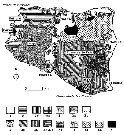
Simpified geological map of Salina, from Barca & Ventura (1993).
1=reworked pyroclastics, undifferentiated
2=pyroclastics of the 3rd Pollara cycle
2a=pyroclastics of the 2nd Pollara cycle
2b=lavas of the 1st Pollara cycle
3=lavas and pyroclastics of the 3rd Monte dei Porri cycle
3a=pyroclastics of the 2nd Monte dei Porri cycle
3b=pyroclastics of the 1st Monte dei Porri cycle
4=pyroclastics of the 5th and 6th Fossa delle Felci cycle
4a=pyroclastics of the 4th Fossa delle Felci cycle
4b=pyroclastics of the 3rd Fossa delle Felci cycle
4c1=Lavas of the 2nd Fossa delle Felci cycle
4c=dacitic lava dome of Punta delle tre Pietre (2nd Fossa delle Felci cycle)
4d=lavas and pyroclastics of the 1st Fossa delle Felci cycle
5=lavas of Corvo volcano
6a=lavas and pyroclastics of the 2nd Rivi-Capo cycle
6b=lavas and pyroclastics of the 1st Rivi-Capo cycle
7=dikes and sills of the shallow feeding systems of Corvo and Rivi-Capo.
Back to The Eolian Islands page
Back to STROMBOLI home page
Back to BB's volcano home page
Visit Other Italian Volcanoes
Last modified on 4 January 1996
Hosted by VolcanoDiscovery