
| Etna
index |
||
| Geology | Geological history | Cones and craters |
| Eruptive characteristics | Eruptions before 1971 | Eruptions since 1971 |
| Etna and Man | References | Web sites |
| Weather forecasts | FAQ | Latest news |
The
Valle del Bove from above and within |
|
 |
 |
Left:
a panoramic view of the southern half of the Valle del Bove from
its western rim, taken in early May 1996. The black lava field on
the valley floor was emplaced during the voluminous 1991-1993 flank
eruption, and in some places has a thickness of more than 100 m.
The morphology of the Valle del Bove was thus significantly changed.
The crest at right is the southern rim of the Valle del Bove, known
as Schiena dell'Asino, and the prominent peak seen on that rim in
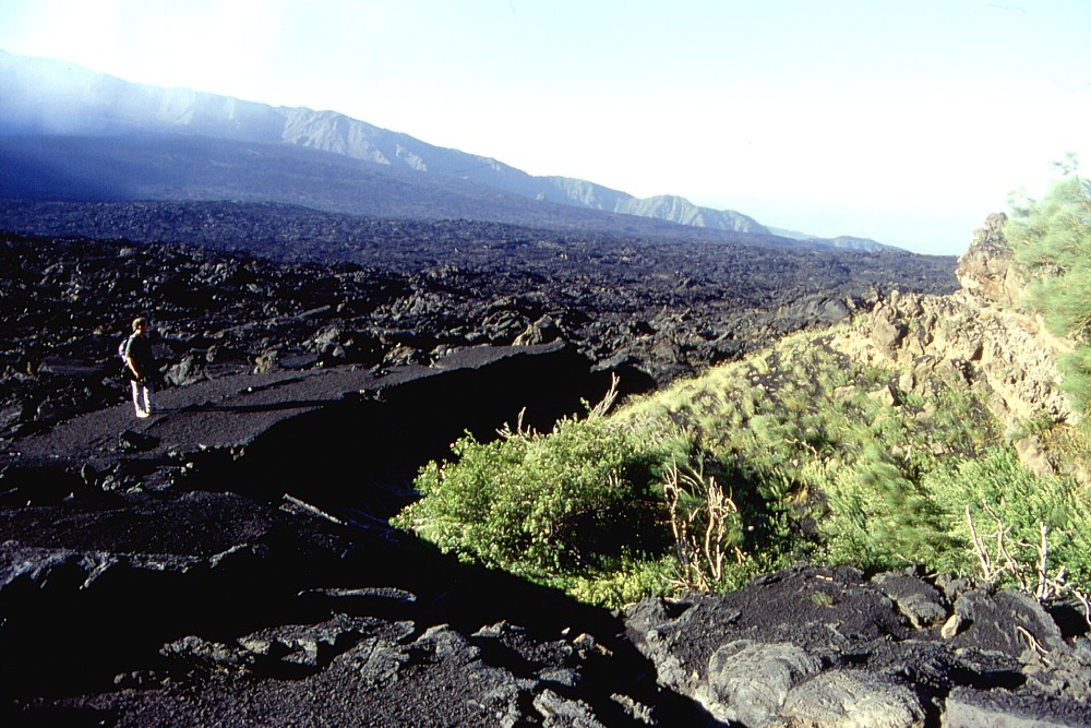
the center distance is Monte Zoccolaro Right: black 1991-1993 lavas on the floor of the Valle del Bove surround a still-vegetated rock outcrop at the base of the south wall of the valley. In the background the valley floor, gently sloping eastward, extends over a distance of 5 km to the northern rim, the Serra delle Concazze. Photo taken in late June 2000 |
|
Morphologic features: The Valle del Bove
A
few thousand years ago, Etna's eastern flank suffered a catastrophic sector
collapse, similar to that of Mount St. Helens on 18 May 1980. This means
that a part of the volcanic edifice slid sidewards, forming a voluminous
avalanche of rock, which rushed towards east, devastating and burying
all that lay in its path, and possibly slamming into the sea. A huge depression
was thus formed in the side of the volcano, now known as Valle del Bove
(Valley of the oxen). Its north-south width is roughly 5.5 km while its
extension from west to east is 7 km. In plan view it is roughly horse-shoe
shaped, resembling a key hole. At its western end, the depression is bordered
by an imposing wall up to 1000 m high (Serra Giannicola area) while it
is open to the east; to the south and north there are spectacular crests
hundreds of meters high from where, on clear days, a visitor enjoys commanding
views of the Valle del Bove and its surroundings. The northern crest,
named Serra delle Concazze, culminates in the Pizzi Deneri, where it actually
delimits a subsidiary depression in the northeastern part of the Valle
del Bove that is known as Valle del Leone (Valley of the lion). The southern
crest is named Serra del Solfizio in its lower (eastern) part and Schiena
dell'Asino in its upper part, which terminates with the prominent pyroclastic
cone of the Montagnola, formed by a flank eruption in June-September 1763.
The origin of the name "Valle del Bove" remains somewhat mysterious.
Actually the name might suggest that it was once possible to use parts
of it as pasture ground for cattle. Presently some 80-90 per cent of the
floor of the Valle del Bove are covered by lavas erupted during the 20th
century, making it one of the most hostile and least accessible areas
on Etna. But this needs not always have been the state of the valley.
There have been prolonged periods when little lava was deposited on the
valley floor, like the 100 years following the 1669 eruption, and probably
also a large part of the 17th century itself. It can be assumed that there
have been similar periods before, when there was enough time for vegetation
growth in the lower part of the Valle del Bove, especially when earlier
lavas had covered by subsequent tephra falls, which facilitates plant
colonization. During the frequent tephra falls from the Southeast Crater
in 2000 a thick layer of scoriae was deposited on the 20th century lavas
in the valley, and in the following spring grass was seen growing in numerous
spots. A still thicker deposit of ash was deposited during the flank eruptions
of 2001 and 2002-2003. If no new lavas bury significant portions of the
area in the near future, the Valle del Bove might assume a green color
within a few years, so that grazing cattle would become possible. Expansion
of herbaceous species was in fact observed during visits to the Valle
del Bove in 2002 and 2003.
| Distant views of the Valle del Bove from the east | ||
 |
These two photographs show the eastern flank of snow-covered Etna in mid-April 1997, with the vast depression of the Valle del Bove opening toward the observer. Left photograph was taken from the area of Giarre to the east of the volcano. A straight view into the Valle del Bove is seen in right photograph, taken from a more southerly location (Guardia area, to the north of Acireale). The two prominent "shoulders" seen on both sides of the summit crater complex are the Montagnola (left) and the Pizzi Deneri (right), which mark the upslope terminations of the south and north rims of the Valle del Bove, respectively |  |
The
Valle del Bove is a key area for studies of the geological
evolution of Etna, for in its walls the traces of numerous older edifices
pre-dating the presently active volcano are exposed. It has been here
that the first evidence for the eventful history of the volcano has been
found in the mid-19th century, and most of what is known now about the
sequence of constructive and destructive events in the course of the past
tens and hundreds of millennia has been derived from geological research
within the Valle del Bove.
The circumstances and age of the collapse event - or series of events
- that generated the Valle del Bove have remained mysterious for a long
time, and a number of hypotheses regarding the origin of the collapse
depression have been forwarded in the past 150 years. Various authors
proposed ages varying between 5000 and 80,000 years of the Valle del Bove.
Lyell (1830, 1849, 1858) discussed various hypotheses regarding the origin
of the Valle del Bove: caldera collapse, marine erosion, and fluvial erosion.
In 1947, the Catania based scientist Vagliasindi published two extensive
papers in which he postulated that not collapse but glacial erosion had
scoured out the Valle del Bove, but this hypothesis was rejected by most
subsequent authors (whereas recent research indicates that glaciers were
indeed present on Etna during the Pleistocene, and possibly into the Holocene).
Klerkx (1970) attributed the Valle del Bove to caldera collapse of the
Trifoglietto edifice (see the chapter on the geological
evolution of Etna), but it is now known that it is much younger than
Trifoglietto, as stated by Guest et al. (1984) who believed that it post-dates
the Ellittico edifice, and thus is younger than about 15,000 years.
| Southern part of the Valle del Bove | ||
 |
Left:
A view from the southern rim of Valle del Bove (Schiena dell'Asino,
see also photo 4) onto the southwestern part of the valley floor covered
with black lava of the 1991-1993 eruption. Note the numerous dikes
outcropping in the flanks above the valley floor - This and the following
three photos were taken on 24 May 1998 Right: Detail of the preceding, with dikes cutting through more erodible pyroclastic deposits in the valley walls |
 |
 |
Left:
Zoom on the lower part of the 1991-1993 eruptive fissure on the southwestern
wall of Valle del Bove. Large upper vent was the site of Strombolian
activity during the first weeks of the eruption while lava flowed
mainly from the vent rimmed by white sublimates further downslope Right: Looking up the Schiena dell'Asino (south rim of Valle del Bove) towards west. Dark cone at the skyline is Montagnola, a cone formed in the summer of 1763 |
 |
Without having any clear evidence (in the form of characteristic debris avalanche deposits such as those known from other volcanoes), various authors speculated that collapse of the Valle del Bove might have been related to a catastrophic gravitational collapse of the eastern flank of the modern Mongibello edifice, similar to the collapse of Mount St. Helens (Washington, USA) on 18 May 1980. Guest et al. (1984) suggest that actually there was a series of such collapse events. These speculations were stimulated by the results of detailed geophysical monitoring of the upper southern flank of Etna during eruptions in the 1980's, in particular the 1983 eruption (Murray and Pullen, 1984) which showed that each time when magma intruded under the flank of the volcano, in a direction more or less parallel to the southwestern rim of Valle del Bove, the area lying east of the intruding dike was forecefully displaced eastwards, that is, in the direction of the Valle del Bove. Indeed between 1983 and 1992, the southwestern rim of Valle del Bove was displaced between 5 and 6 m eastwards during four major events, increasing the instability of the steep western face of the Valle, and causing concern about future catastrophic collapse of that area. Until very recently, however, no deposits that could be clearly attributed to sector collapse and a resulting debris avalanche were found. Such deposits were believed to lie buried below a thick succession of fluvial debris and conglomerates, known as the Chiancone, on lower eastern flank of Etna below the eastern mouth of Valle del Bove and thus hidden from exposure. Calvari et al. (1998) finally succeeded in finding debris avalanche deposits in a few outcrops of the Chiancone area and thus found firm evidence for a debris avalanche responsible for at least the initial stage of formation of the present Valle del Bove. They reported a minimum age of 8400 years for the debris avalanche deposit and infer that the Chiancone deposits derive from remobilization and later fluvial reworking of the deposit.
| Northern part of the Valle del Bove | ||
 |
Left:
Northern part of the Valle del Bove as seen from its northern rim
(Serra delle Concazze) on 23 June 1998. Dark lava flows visible on
valley floor are of the 1986-1987 and 1989 eruptions. Note dikes in
foreground. The cone seen on the valley floor in the center is Monte
Simone, formed during an eruption in 1811-1812 Right: Upper northeastern part of Valle del Bove and the morphological step where the valley passes into the Valle del Leone, seen from the Serra delle Concazze on 23 June 1998. The reddish-oxidized cone and dark lavas extending downslope from it were formed during the 1986-1987 eruption. In the background lies the summit crater complex, with the then still small cone of the Southeast Crater at left and the broad cone of the Northeast Crater at right |
 |
But the fascinating story of the study of the Valle del Bove does not end here. During the past few years a group of scientists from Manchester University (U.K.) and the Benfield Greig Hazard Research Centre (London, U.K.) has done research on features related to what they believe was the pre-collapse volcanic edifice, and the preliminary results of these studies are intriguing (Deeming et al. 2001; K.R. Deeming, personal communication, 2003). Using abundances of a rare isotope of helium, 3He, for dating of rocks in an area known as "Acqua della Rocca" on the outer wall of the Valle del Bove on the southeastern flank of Etna, they revealed that the catastrophic collapse of the Valle most likely occurred about 6800 years ago - still more recently than the date given by Calvari et al. (1998). To arrive at this age, they measured the abundance of a rare isotope of helium, 3He. This isotope appears in rocks exposed to cosmic rays that enter the Earth's atmosphere - that is, rocks that are not covered, for instance, by flowing water in rivers. The duration of exposition of a rock can be measured from the abundance of 3He isotopes. Such measurements were made in various fluvial features (valleys of rivers or torrents) that extend from the Valle del Bove rim down the outer slopes of the volcano. The existence of these incisions shows that water once flowed here and was fed by sources on a higher slope that disappeared when the Valle del Bove collapsed, causing the cessation of water flow. Prior to collapse, there were probably ice and snow fields in the summit area of the volcano, which fed a number of rivers and torrents. One of these palaeorivers flowed through a narrow valley on the southeast flank of Etna, now known as "Acqua della Rocca".
Acqua
della Rocca - the tell-tale river that is no more |
|
 |
 |
A
popular hiking trail leads from a parking lot at the Piano del Vescovo,
on the southeastern flank of Etna, through a narrow valley that
cuts through the rim of the Valle del Bove. This valley is locally
known as "Acqua della Rocca", and besides being one of
the most charming places on the volcano, it also holds some of the
secrets related to the collapse of the Valle del Bove. Left photograph
shows the view from below through the valley, with the cone of the
Southeast Crater looming above the deep gap that the valley forms
in the Valle del Bove rim. The opposite view, looking down through
the valley, is seen at right. The fact that the valley forms such
a prominent gap in the Valle del Bove rim indicates that it once
continued upslope - on a slope that does no longer exist, because
it was removed when sector collapse led to the formation of the
Valle del Bove, some 6800 years ago. Photographs were taken in June
and May 2000, respectively |
|
 |
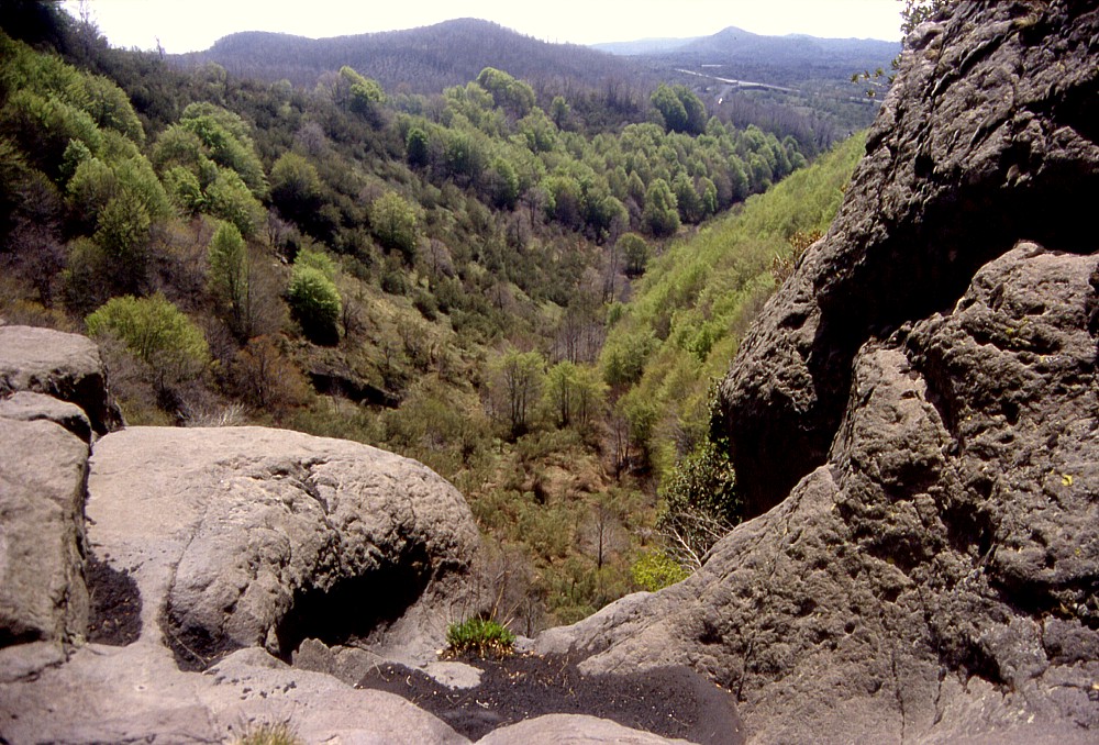 |
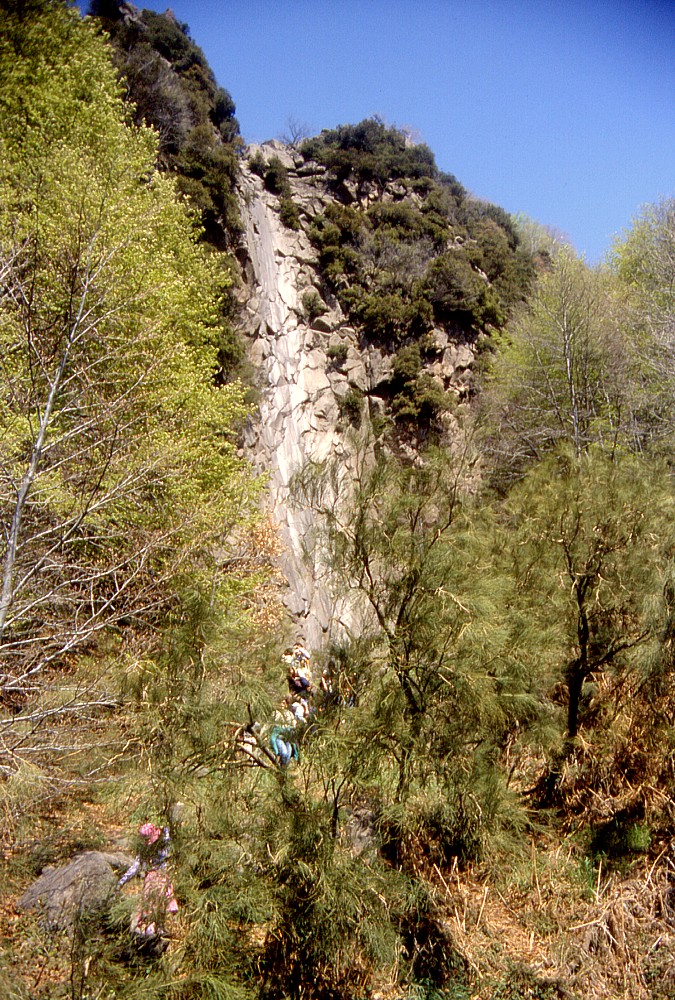
One
of the most characteristic feature of the "Acqua della Rocca"
valley is the steep cliff about halfway up the valley, seen from
below (left) and above (right) in these photographs, taken in May
2002. The polished surface of the cliff indicates that once water
formed a cascade, about 80 m high, but the cascade has disappeared.
Dating of helium isotopes in the polished rock surface indicates
that continuous flow of water ended about 6800 years ago |
|
The
valley locally known as "Acqua della Rocca" (formally named
Vallone Acqua Rocca degli Zappini) forms a deep notch in the rim of the
Valle del Bove that is clearly visible above the Piano del Vescovo, a
popular picnicking area for local people on sundays and holidays. A hiking
trail leads up through the narrow valley, through lush forests, to the
rim of the Valle del Bove, from where there is a breathtaking view across
this enormous, lava-covered depression. About half way up in the "Acqua
della Rocca" valley, there is a steep scarp about 80 m high, which
appears strongly polished in its central portion. This effect is a result
of water that once cascaded down the scarp, forming a spectacular fall.
However, water has ceased to flow through the valley and down the scarp
long since, because the source of the water disappeared. The studies carried
out by the Manchester group of scientists revealed that the cessation
of water flow coincides with the collapse of the slope of the volcano,
which led to the formation of the Valle del Bove.
Apart from being a key location for the reconstruction of the events associated
with the Valle del Bove collapse, the "Acqua della Rocca" valley
is one of the most scenic areas for relatively easy and short hikes on
Etna. It is easily accessible because one of the main roads leading to
the tourist area of Rifugio Sapienza on the south flank passes nearby.
The hike initially leads into the lower outlet of the valley up to the
base of the scarp with the dried-out water fall, where it begins to climb
more steeply; stairs have been constructed to facilitate the climb up
to the upper edge of the scarp. Here hikers are invited to rest and enjoy
the beautiful view down the scarp into the lower portion of the valley
and across the lower southeastern flank of Etna to the Acireale area.
The climb then continues across dense vegetation, and the path is slightly
more difficult to follow. The last part of the climb is steep and has
to be made on loose sand, which renders it less pleasant than the first
part of the hike. But at the end of the climb one is rewarded by a stunning
view into the Valle del Bove (of course, only if there are no clouds)
up to the summit craters. The steep wall of the Valle del Bove is cut
by spectacular dikes, and below the valley floor is made up of lavas of
the 1991-1993 eruption, which in some places reached thicknesses in excess
of 100 m.
Although most hikers might initially feel exhausted after the steep climb
to the Valle del Bove rim, there is still the possibility to descend from
here to the floor of the valley. Actually, this is one of the easiest
places to enter into the Valle del Bove, the descent taking no more than
about 15 minutes (although it has to be recalled that the return starts
with the steep climb out of the Valle del Bove). A visit to the Valle
del Bove floor yields impressive views of the 1991-1993 lavas and the
steep south wall of the valley, which is traversed by countless dikes
that testify to flank eruptions in the past.
More information regarding hikes into the Valle del Bove (there are essentially
three itineraries) will be posted on a separate page.
REFERENCES
Calvari S, Tanner LH and Groppelli G (1998) Debris-avalanche deposits of the Milo Lahar sequence and the opening of the Valle del Bove on Etna volcano (Italy). Journal of Volcanology and Geothermal Research 87: 193-209.
Coltelli M, Del Carlo P and Vezzoli L (2000) Stratigraphic constraints for explosive activity in the past 100 ka at Etna volcano, Italy. International Journal of Earth Sciences (formerly Geologische Rundschau) 89: 665-677.
Deeming KR, Harrop PJ, Turner G and McGuire WJ (2001) Catastrophic lateral collapse at Mount Etna in historical times (abstract). European Geophysical Society, 26th General Assembly Nice (France).
Guest JE, Chester DK and Duncan AM (1984) The Valle del Bove, Mount Etna: its origin and relation to the stratigraphy and structure of the volcano. Journal of Volcanology and Geothermal Research 21: 1-23.
Lyell C (1830) Principles of Geology (1st edition). J Murray London.
Lyell C (1849) On craters of denudation, with observations on the structure and growth of volcanic cones. Quarterly Journal of the Geological Society of London 6: 209-234.
Lyell C (1858) On the structures of lavas which have consolidated on steep slopes; with remarks on the mode of origin of Mt. Etna, and on the theory of "Centres of Elevation". Philosophical Transactions of the Royal Society of London 148: 703-786.
Kim Deeming (Isotope Geochemistry Group, Manchester University, U.K.) is acknowledged for permitting the presentation of preliminary information about research on the Valle del Bove collapse on this site, and for submitting updated information. A publication on this subject is in preparation.
Copyright © Boris Behncke, "Italy's Volcanoes: The Cradle of Volcanology"