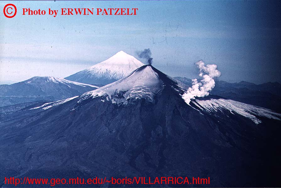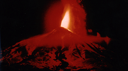
The eruption of Villarrica in the night of 2 March 1964. Photo by Erwin Patzelt
Villarrica volcano, Chile
The eruption of Villarrica in the night of 2 March 1964. Photo by Erwin Patzelt
Villarrica volcano, Chile
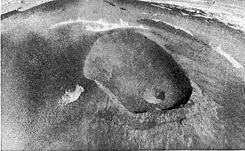
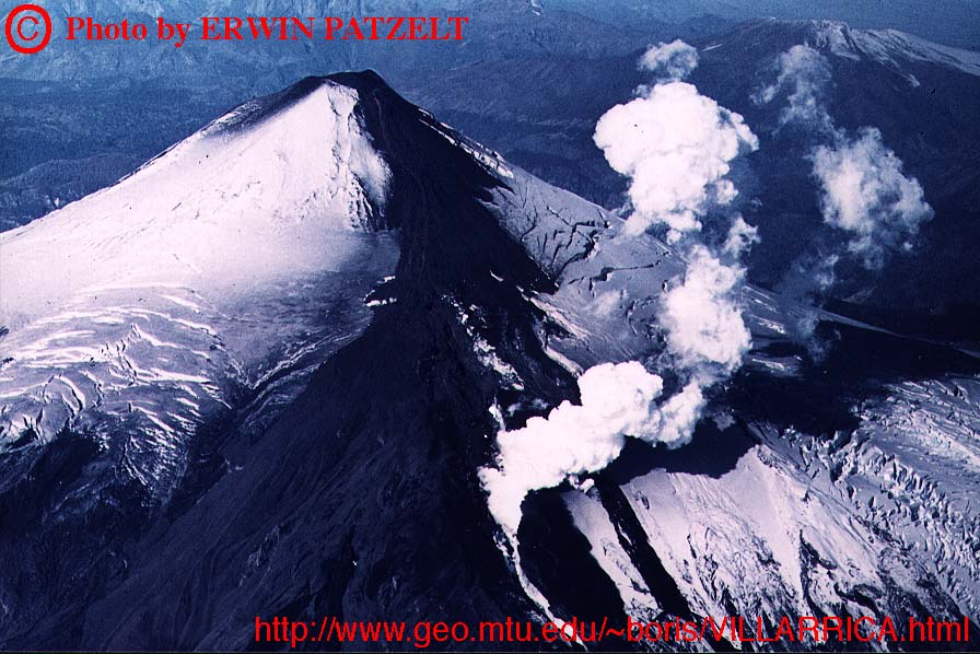
Summit crater filled with a growing cinder cone
(Full picture JPEG: 72K)
Aerial view of the summit of Villarrica during the first stage of the 1963 eruption, March or April 1963. The crater is completely filled with a new cinder cone whose active vent is visible in the lower right (northeast?) part of the main crater. Photo taken from Casertano (1963b).
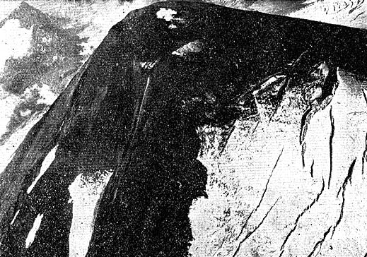
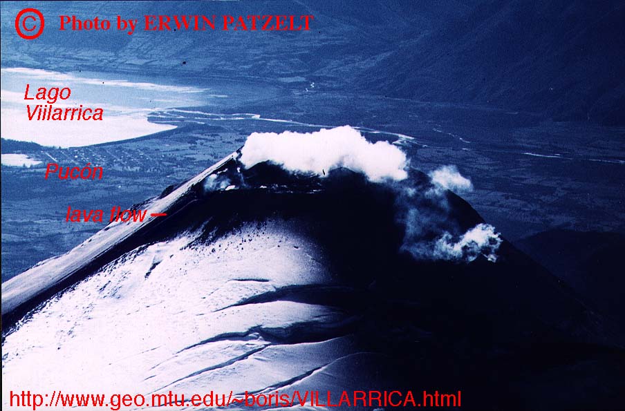
Summit of Villarrica with lava flow
(Full picture JPEG: 95K)
Villarrica's summit seen from S (?) on 21 May 1963. A brightly incandescent lava flow is visible in the center of the photograph. The summit area is darkened from recent tephra falls, and conspicuous fracturing of the glacal icecap is visible in the lower right corner of the image. Photo taken from Casertano (1963b).
The 1963 eruption may be considered typical for Villarrica; nonetheless, there is only one detailed report about it (Casertano 1963b). Activity began with the formation of a cinder cone within the summit crater on 8 March 1963 when weak Strombolian explosions were observed. The magma column continued to rise during the following 4 days, and on early 12 March, a lava flow began to issue from a vent situated about 250 m below the summit. During the afternoon of that day, dark ejecta con-taining blocks 30 cm in diameter rose 100 m above the summit. The subterminal lava flow on the WSW flank was brilliantly incandescent along its upper 250 m below which it was covered with a solid crust.
The eruption continued much the same way through 19 March, after which only steam emission from the summit was observed. The lava flow had stopped after reaching a length of about 1 km.
Summit explosive activity resumed on late 13 April, and on the following day, a new lava flow descended along the earlier flow, this time being fed by two boccas within the summit crater while there were no significant explosive phenomena. Poor weather prevented detailed observations of the volcano during the following days, but on 22 April, rivers draining N flank of the volcano showed increased discharge rates. No significant activity occurred in late April.
At about 1500 on 2 May, after a series of earthquakes, a dense column rose from the summit to attain a height of about 1.5 km, causing ash and lapilli falls in the town of Pucón. The volcano was veiled by clouds until about 1830 when a new lava flow was seen descending the W (?) flank. Dense vapor clouds were produced where the lava interacted with snow and ice, and meltwater floods rushed down the N flanks of the volcano, destroying a bridge between the towns of Pucón and Villarrica.
Lava emission continued for a couple of days, followed by a period of quiet that was in turn followed by another eruptive episode on early 21 May. On that morning, a new lava flow issued from the summit crater and overflowed onto the SW flank. Rapid melting of snow triggered flash floods that devastated areas along the Seco, Escorial, and Chaillupén rivers. Several buildings and three bridges were destroyed, and there may have been fatalities (Volcanoes of the World, 1994 edition).
Lava extrusion continued for several days afterwards, and on 25 May, the volcano had become completely quiet. It is, however, possible that activity resumed shortly after the end of Casertano's observation period in May 1963 (Casertano was transferred to Italy and there were no more observations of the volcano by trained observers through the remainder of the 1960's).
The destructive eruption on 1-3 March 1964 is generally listed as an isolated event but recent research of contemporary sources and eyewitness accounts as well as newly supplied photos indicated that this event was preceded by at least several weeks of effusive and weak explosive activity. Press reports (e.g., "Die Welt", 4 March 1964) mention that Villarrica had become active "for the second time in two weeks" and an eyewitness account published in the "Franziskusblatt" (Altötting, Germany; vol. 65, Nov. 1964) says that residents living near the volcano had observed activity (probably Strombolian explosions) for several weeks.
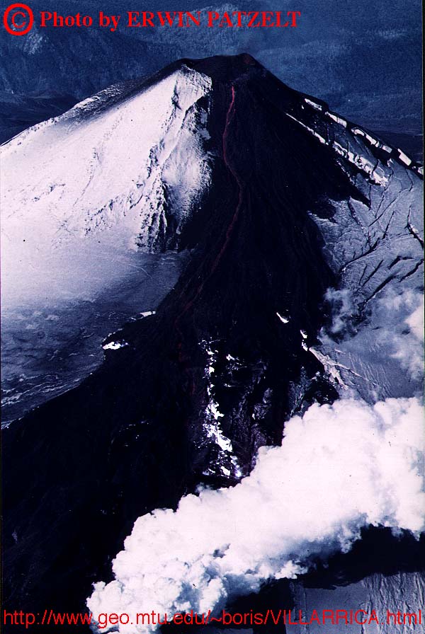
Erwin Patzelt who was in Chile during the early 1960's overflew the volcano twice in late 1963/early 1964 (see photos below), once probably during the Austral summer (when there was little snow on the summit) and the second time shortly before the 1-3 March event. On both occasions, lava was pouring from the summit crater. The earlier overflight revealed the absence of any large intracrateral cone but complex collapse structures at the summit, and a thin lava river running downslope on the SW flank. Tephra had been deposited on the snow on the E flank. During the second overflight, the summit crater was filled with a large tephra hill and an active cinder cone sat asymetrically in the S part of the crater. A compound field of numerous overlapping lava flow lobes had formed on the SW and W flanks, many of the lobes having covered the summit icecap rather than melting it, but lahars had been generated at somewhat lower elevations. An active lava flow was running downslope to about 1.5-2 km from the summit, its front interacting vigorously with glacial ice. Recent lahar deposits reached the base of the volcano.
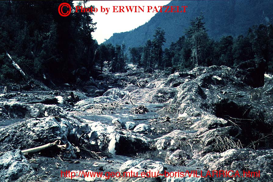
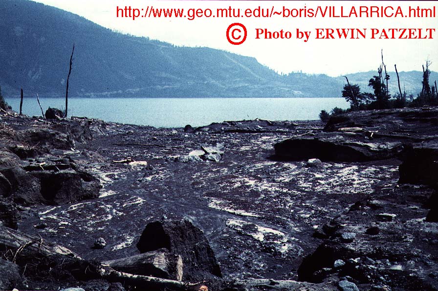
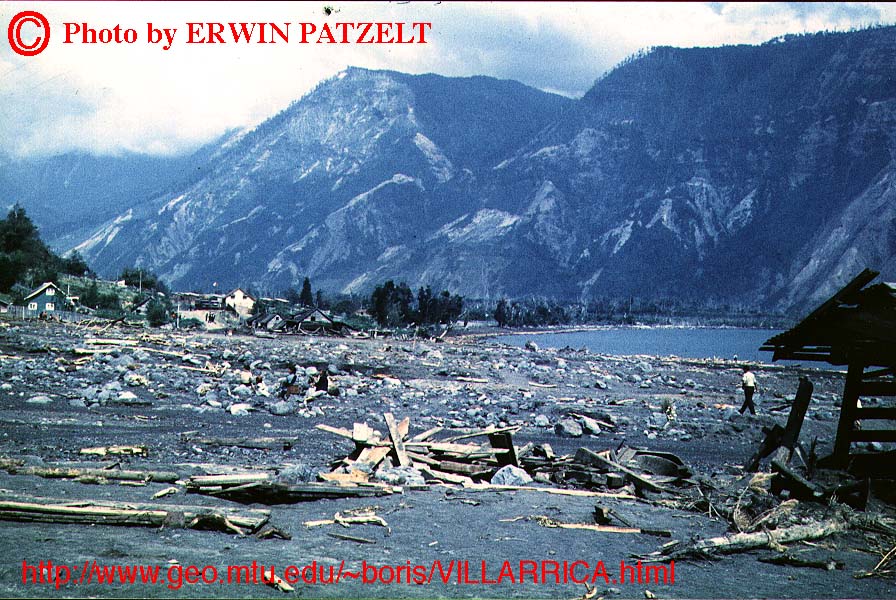
The culmination of this activity came late on 1 March when a lava fountain shot to about 500 m above the summit from the crater and a short new fracture on the upper SSE slope. Rapid melting of snow and ice caused large lahars and meltwater floods that rushed down the Diuco river and destroyed about 50% of the town of Coñaripe. At least 25 people were killed. This eruptive event was characterized by high eruption rates and the partial splitting of the cone's uppermost portions, leading to the generation of the devastating mudflows. During the days after the disaster, activity at the volcano rapidly decreased.
There seems to have been little activity for the next 7 years. An overflight by Mrs. Hennecke in mid 1970 or 1971 revealed that the summit crater contained a large pit (caused by the collapse of the 1964 cone). The pit was covered with snow, and not even fumarolic activity was occurring.
Copyright © Erwin Patzelt, 1964, 1996
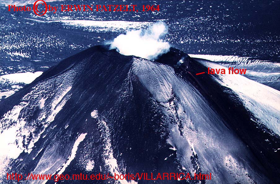
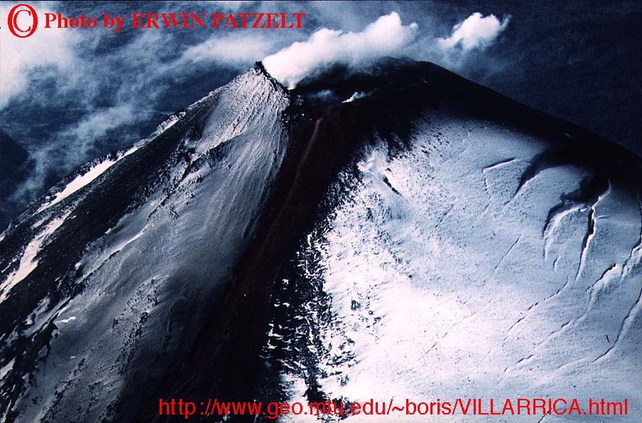
Villarrica from West, late 1963/early 1964
(Full picture JPEG: 165K)
Aerial view of Villarrica's summit area, looking east. The summit crater is filled with steam, so no details of its inner structures are visible. A lava flow is issuing from the lowest point in the SW crater rim (right). Photo Copyright by Erwin Patzelt, 1964; 1996.