Until mid-January 1973, Heimaey was considered volcanically inactive both by volcanologists and its residents. Thus, the eruption came as a complete surprise. Premonitory seismicity was registered on seismographs in South Iceland, but at that time no seismic network existed, there was no way of precisely locating the epicenters of the tremors, and an eruption from Katla volcano would have been considered more likely at that time. A swarm of earthquakes began on the evening of 21 January 1973, with 200 events registered during a 14 hour period. Focal depths were below 20 km depth. A second seismic swarm began at 2200 on 22 January. These events were much shallower and some of the tremors were felt on Heimaey. The strongest of these events had a magnitude of 3.
The day before the eruption, on 22 January, a gale had raged in the Vestmannaeyjar region, and numerous ships had sought shelter in the harbor of Heimaey. During the night of 22-23 January, there were 70 ships present in the harbor, a coincidence that would soon yield invaluable help. During the evening of 22 January, the gale ceased, the all was tranquil by midnight.
 (15 kb JPG image)
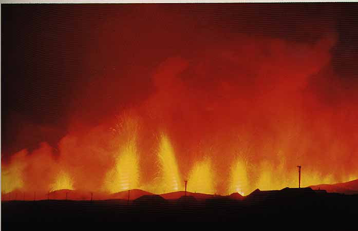
This is how the eruption on Heimaey looked like during its first few hours, on 23 January 1973, when the eruptive fissure was active along its full length. About 40 lava fountains shot up immediately behind the easternmost homes of Vestmannaeyjar, visible in the foreground. Photo is from H. R. Bárdarsson's gorgeous 1982 book entitled "Iceland, a protrait of the country and its people".
The eruption began a few minutes before 0155 on 23 January from a 1.6 km long, NNE-SSW striking fissure that opened on the NE side of the island, running from the N rim of the Saefjall explosion crater, across the E flank of Helgafell, to the NE tip of the Helgafell lava field. The fissure was located only about 200 m from the E margin of the town, an uncomfortably close distance, but fortunately it lay on a terrain gently sloping away from the town. About 40 lava fountains shot up into the sky, and soon after the beginning of the eruption, lava began to flow out, away from the town thanks to the favorable morphological situation. A light wind sprang up, blowing from the W which is quite unusual at that time of the year, but it carried the incandescent pyroclastics ejected from the fissure away from the town.
Thus, a coincidence of several factors helped that the eruption did not immediately assume disastrous proportions. The residents of the town left their homes quietly and went to the harbor where they were taken aboard the large fleet of ships available for evacuation. There have been few instances where a volcanic emergency situation was handled so smoothly, but much of this was due a number of factors which, had they varied just a little bit, might have resulted in a tragedy. The fissure could as well have opened right across the town. It could at least have done so on the side of the minor crest towards the city thus letting the lava flow right into town. There could have been a wind from the predominating direction, carrying glowing tephra towards the houses. Conditions changed soon after the successful completion of the evaciation.
 (23 kb JPG image)
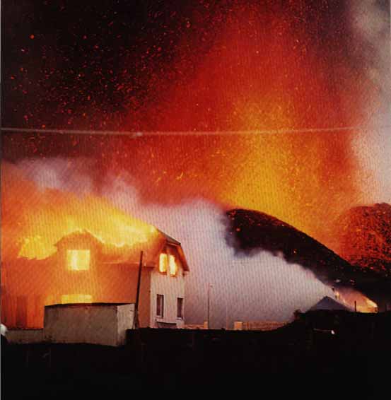
During the first days of the eruption, incandescent tephra frequently fell onto the E part of the town, closest to the active vents. One after another, the houses in that area were hit by large bombs and incinerated. The photo was scanned from "Volcano, Ordeal by fire in Iceland's Westmann Islands", published in 1973 by Iceland Review, Reykjavik.
After the first day, the eruptive activity concentrated at a section of the fissure where the fountains became more vigorous and a new volcanic edifice began to grow. This active section of the fissure was right where it lay closest to the nearest houses. With the wind soon returning to its prevailing seasonal directions, glowing spatter were carried over the town, and numerous houses immediately caught fire. One month after the onset of the eruption, more than 100 homes were thus destroyed.
 (18 kb JPG image)
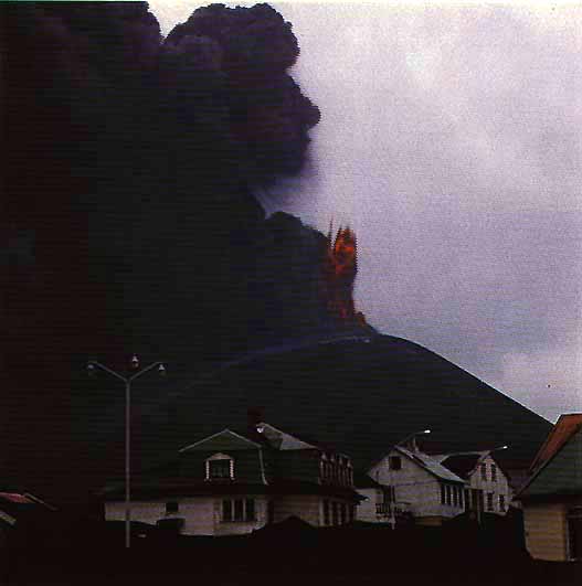
At the end of January 1973, only a few vents remain active along the eruption fissure. They began to build up an elongate ridge of pyroclastics that informally was named "Kirkjufell" (Church Mountain) by the residents. Later, the Icelandic commission for geographic names decided to call the new volcanic feature "Eldfell", Fire Mountain. The photo shows the main fountain to the right and a dense ash column rising from a smaller vent to the left of it. The remains of a burned house are visible in the foreground. The photo was scanned from "Volcano, Ordeal by fire in Iceland's Westmann Islands", published in 1973 by Iceland Review, Reykjavik.
The new volcano continued to grow vigorously during the first half of February, reaching more than 220 m on the 15th. Due to the prevailing winds, growth was most vigorous on the side of the crater wall facing the town, and much of the finer-grained pyroclastics gradually buried large portions of the town. Houses that were not burned by the impact of incandescent bombs collapsed under the weight of tephra which in the easternmost part of the town exceeded 2 m in thickness. The photo below shows the cone at its maximum height.
 (18 kb JPG image)
Eldfell cone when it was highest, surpassing 220 m in mid-February. Homes in the foreground are partially buried under tephra but have been repeatedly dug out by volunteers. Photo is from H. R. Bárdarsson (1982) "Iceland, a protrait of the country and its people".
On 19 February, the W rim of the crater immediately above the town that had grown unstably steep in the previous weeks collapsed. This collapse was probably triggered by the pressure exerted on the crater wall by a lava lake rising within the crater. The collapsed portion of the crater wall slid a few hundred m across the eastern part of the town, burying numerous houses. At around the same time, volcanic gases (CO2 and CO) at toxic levels were discovered in the urban area. One month after the beginning of the eruption, the hope of a salvation of the town began to fade. Meanwhile, lava continuously moved towards the harbor entrance, threatening to close it. The flow destroyed the electricity cable and one of the two freshwater supply tubes connecting Heimaey with the "mainland".
Nonetheless, from the beginning of the eruption, efforts were made to reduce as much as possible the destructive effects of the eruption. A crew of about 250 volunteers remained on the island, trying to salvage as much as possible. They removed the tephra fallen on the buildings and carried households from homes that were doomed before they were crushed by lava. All windows facing the volcano were covered with corrugated iron in early February to prevent glowing bombs from crashing into the houses through the windows. Protective barriers were built up along the W margin of the lava field, in order to prevent its westward spread. The lava field on the E side of the fissure had soon built up such that all new lava was channellized towards the harbor and closer and closer to the town. In mid-March, a broad lava tongue swept over the protection barriers and right into the center of the town. In the course of a few days, hundreds of houses and several large fish factories were crushed and buried. Efforts to halt the lava by spraying water onto its front failed due to the high mobility of this flow.
Following the late March surge of lava effusion into the town, cooling of the lava by spraying sea water onto it was performed at ever increasing scale. A vast pumping and plumbing system was installed, carrying sea water closer and closer to the source of the lava. That way it was hoped to stop the lava from moving towards the harbor and filling more and more of its entrance. In mid-April, the major concern was the presence of toxic CO gas in the town which claimed the only fatality related to this eruption. The eruptive activity itself showed a gradual decline, and by late May a positive feeling was prevailing among the displaced residents. Some of the fish factories that had escaped destruction from the March lava flow resumed production.
The eruption ended on 25 June (but was officially declared over only on 4 July) 1973, after about 5 months. By that time, more than 400 buildings had been buried and collapsed under the weight of tephra, burned by bombs or crushed by lava. Rehabilitation of the town was immediately resumed, and by late 1973, more than 2000 of the island's originally 5300 residents were again living on Heimaey.
The eruption was not a particularly large eruptive event for Iceland standards. The total volume of erupted material was about 250 million cubic meters, most of which was lava. The Surtsey eruption had delivered four times as much magma. The new volcanic cone, Eldfell, a horseshoe-shaped tephra wall open towards the N, was 215 m high. The island had been significantly enlarged towards the NE by lava flows. The total subaerial area newly created was about 2.2 km^2.
NOTE: These chapters will gradually grow and live from contributions by Richard Kölbl who does invaluable translation work from Icelandic sources inaccessible to many volcanophiles. Have a little patience!
Go to Erling Árnason's marvellous Heimaey homepage, a new site offering marvellous images of the island and the 1973 eruption. On those pages you will find what you are missing here!
Various aspects of Heimaey and the 1973 eruption