|
Etna produced its
most voluminous and longest-lasting flank eruption since about 300 years
between 14 December 1991 and 30 March 1993. Much of the southern part
of Valle del Bove was filled with a thick compound lava field, with maximum
thicknesses exceeding 100 m. About 205-250 m3 of lava were produced during
the 473 days of the eruption at an average rate of 5-6 m3 per second.
The eruption, though not particularly vigorous in terms of explosivity
and eruptive rates, became the most publicized eruptive event at Etna
so far, mostly due to the (at least partially) successful diversion of
lava flows that threatened the town of Zafferana Etnea. The lessons from
the 1991-1993 eruption should, however, not imply that man is now capable
of controlling the volcano. Several favorable factors allowed the relatively
successful lava diversion:
1) the low effusion rate. At a higher effusion rate, lava may have been
delivered through more than one main lava tube or flow channel, which
would have rendered any effort of diverting the lava more difficult. In
other flank eruptions with high effusion rates, such as that of 1981
on the NNW flank, broad, voluminous lava flows advanced very rapidly towards
towns and agricultural areas, without forming significant flow channels
or tubes, and therefore no diversion would have been possible.
2) the high elevation of the eruptive vents. The eruptive fissure lay
between 2350 and 2200 m altitude and therefore far away from inhabited
areas. The lava flow had to travel about 8 km before it became a serious
threat, and it took about 4 months to cover this distance. In the 1981
eruption, the lowest eruptive vents lay at 1150 m elevation, and the main
lava flow covered a distance of almost 8 km in little more than 40 hours.
3) the drop in the effusion rate shortly after the final blasting operation.
After that operation, carried out on 27 May 1992, lava did not travel
much farther than 3 km from the diversion site. Had the effusion rate
remained constant, then it would have been easy for the lava to build
another lava tube system similar to that formed in the first months of
the eruption, and this could have led to another advance of the lava fronts
to the area of Zafferana.
4) the possibility to divert the lava far away from the threatened areas.
The diversion was carried out at little below 2000 m elevation, and about
7 km from the nearest village. It did thus not result in a new threat
to another area, because all the diverted lava could accumulate in an
uninhabited area, far away from cultivated or inhabited land.
Map
of the 1991-1993 lava flow-field
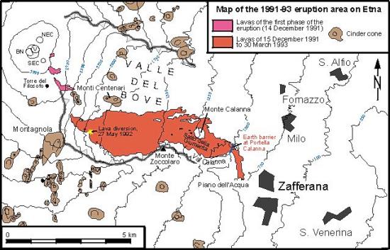
Map
of the eastern flank of Etna, showing the lava flow-field of the 1991-1993
eruption in the southern part of the Valle del Bove, and key locations
related to events during the eruption. The lavas erupted during the first
phase of the eruption (14 December 1991) are shown in different color
than the main lava flow. After the final diversion of the lava flow on
27 May 1992 (the site of this operation is indicated by a yellow asterisk),
lava continued to accumulate only in the upper third of the lava flow-field,
in the area where it is largest
|
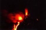
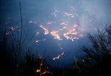
Left:
Strombolian activity and lava emission from the main eruptive fissure
onSW wall of Valle del Bove, seen in late-December 1991 from the Monte
Zoccolaro area on the S rim of the Valle. Explosive activity at this
fissure lasted only a few weeks, but lava continued to flow for one
year and three and a half months, making this the longest eruption
of Etna since the 1614-1624 eruption, and its most voluminous eruption
since1669. However, the effusion rate was low: in 1669, about three
times as much lava was produced in four months
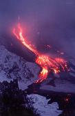
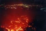
Right: Lava flows spilling down into the Valle del Bove at nightfall
in late-December 1991, seen from the same viewpoint as photo at left.
Both photos were taken by Carmelo Monaco |
|
|
Lava
flows in the Valle del Bove on the evening of 20 March 1992, seen
from Monte Pomiciaro on the S rim of the Valle. Lava issues from countless
ephemeral vents (that is, short-lived vents where lava broke to the
surface from lava tubes) as can be seen in both images. The photo
at right shows the view down across the Val Calanna, an offspring
of Valle del Bove near its SE end. Lava is gradually filling a basin
behind an artificial earth barrier intended to halt the approach of
the flow towards Zafferana |
|
|
Left:
Lava in Val Calanna, above Zafferana which is out of the view to the
right, on the evening of 20 March 1992. View is from Monte Pomiciaro.
Lights in the background are of the villages of Milo and Fornazzo,
not threatened by the lava flow.
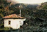
Right: One of the few buildings destroyed by the 1991-1993 lava flow
near Zafferana. The owner wrote "Grazie governo" (Thank
you Government) on its wall before it was surrounded by the lava flow,
hinting to the "inactivity" of the authorities. Attempts
to divert the lava were undertaken shortly after. Photo was taken
almost one year after destruction, in February 1993 |
|
The
following photos were taken by Giuseppe Scarpinati |
|
Photos
taken on 1 January 1992, about two weeks after the onset of the eruption.
Left photo shows lava spilling down the Salto della Giumenta, above
Val Calanna. Right photo is a panoramic view of the southern part
of the Valle del Bove with lava flows issuing from the eruptive fissure
on the SW wall of the Valle, seen from Monte Zoccolaro on the S rim
of the Valle del Bove |
|
|
Photos
taken on 4 January 1992.
Left: Black lava covers the Salto della Giumenta at left, and accumulates
at its base in Val Calanna. The low hill in the center of the image
is Monte Calanna
Right: In an effort to halt the advance of the lava, an earth barrier
is built across the outlet of Val Calanna, above the town of Zafferana |
|
|
Two
close-up views of flowing lava in the upper Valle del Bove on 7 March
1992. Right photo also shows a peculiar natural sculpture at upper
left, possibly a remainder of a drained lava tube |
|
|
Active
lava lobe extruding from an ephemeral vent (a vent located at the
lower end of a lava tube) in Val Calanna, on 8 March 1992. The lava
is gradually filling the basin behind the artificial earth barrier
erected two months earlier; one month after this photo was taken,
the lava spills over the crest of the barrier
|
|
|
|
Left:
Giuseppe Scarpinati standing on what a few days before was the crest
of the earth barrier, next to lava spilling over the barrier into
a narrow valley leading directly towards the town of Zafferana. Three
smaller barriers are hastily erected at ever lower elevations in that
valley, only to be overrun after few hours by the advancing lava.
Photo was taken on 11 April 1992
Center: A
flow of bulbuous lava is burying a vineyard at painfully slow speed
in a locality known as "Piano dell'Acqua" near Zafferana,
as the lava flow is approaching alarmingly close to the eastern part
of the town. This photo was taken on 25 April, when the first major
surge of lava towards Zafferana occurred
Right: A
view towards W from the hills above Zafferana on 26 April 1992. Steaming
lava is seen at left in the Val Calanna, from where the lava continues
to flow towards Zafferana. The W wall of the Valle del Bove, covered
with snow, is visible in the background |
|
Left:
An isolated building at Piano dell'Acqua above Zafferana,
shortly after its destruction, on 9 May 1992, with an acknowledgement
to the Italian government written on its wall by the owner. The
lava has temporarily ceased advancing in the direction of Zafferana
Right: A
tongue of lava is burning trees above Zafferana, 9 May 1992
|
|
|
Lava
flows burying fruit gardens above the Piano dell'Acqua,
9 May 1992. This spring is the last for many of the trees visible
in these photos
|
|
|
The
winter of 1992-1993 has draped a thick white blanket over Etna,
but the lava field forming since late 1991 remains black: lava is
still flowing from the eruptive fissure, visible at the extreme
left on the SW wall of the Valle del Bove. The photo was taken on
16 January 1993 from Monte Zoccolaro, which carries a large steel
cross. Lava effusion ends in late-March 1993
|
Continue
with
THE 1995-2001 SUMMIT
ERUPTIONS
|