
| Etna
index |
||
| Geology | Geological history | Cones and craters |
| Eruptive characteristics | Eruptions before 1971 | Eruptions since 1971 |
| Etna and Man | References | Web sites |
| Weather forecasts | FAQ | Latest news |
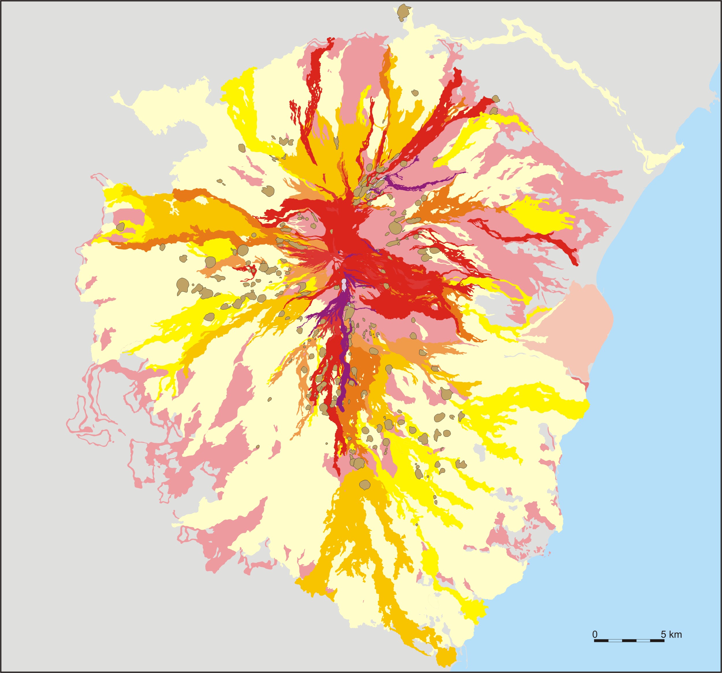 |
| Geological
map of Mount Etna, highlighting the pyroclastic cones dotting the
flanks of the volcano (in brown color with black outlines). The
pre-Etnean sedimentary basement is shown in grey color, whereas
volcanic products older than Holocene are shown in pink. Holocene
but prehistoric lava flows of Etna are light yellow, lavas erupted
between during the early historical period through 1600 are shown
in full yellow, and flows starting from 1600 are shown in various
shades of orange over red to purple, with one color applied per
century. The lavas of the 20th century are thus shown in red, and
those of the 2001 and 2002-2003 eruptions in purple color |
Mamma
Etna's countless children
The craters and cones on the flanks of Mount Etna
![]()
Among the
various superlatives that apply to Mount Etna is the enormous quantity
of eruptive centers on its flanks, which occur as cones, craters, and
fissure vents. No less than 319 individual flank cones on Etna's flanks
were identified by Mazzarini and Armienti (2001), occurring between
475 and 2990 m elevation. These do not include the new cones formed
during the 2001 and 2002-2003 eruptions - three large (>100 m tall)
and four smaller (a few tens of meters tall; one of these, formed in
2001, has been buried by pyroclastics of the 2002-2003 eruption) as
well as about 40 smaller vents ranging in size from a few meters and
sometimes crowning hornitos, to tens of meters wide but lacking significant
pyroclastic edifices.
Flank cones occur on all sides of Etna but their concentrations vary
strongly from one area to another. Three sectors are particularly rich
in such cones, namely the middle to lower southern to southeastern sector,
the middle western flank, and the northeastern flank, including the
Northeast Rift. It seems that larger cones tend to occur in the lower
portions of these areas whereas higher upslope smaller cones, hornitos
or craters without cones are more common. The large cones formed during
the 2001 and 2002-2003 eruptions are a notable exception for they formed
above 2500 m altitude, where until then flank cones had been extremely
rare - only a single significant older cone, Monte Frumento Supino,
on the upper southern flank, lies at about 2850 m elevation.
A peculiar feature of these eruptive centers on the flanks is that each
erupts only one single time during its lifetime. This is due to the
fact that none of them is fed by a long-lived conduit (differently from
the summit craters, whose conduits are permanently supplied with magma).
They form during instantaneous intrusive events that end when magma
supply ceases. On the other hand, new eruptions may occur by coincidence
at the site of a previously existing cone, once a new dike intrudes
in that site, but this is not a reactivation of the conduit that once
fed the old cone. A rare case of this type occurred in 1923 when a short
eruptive fissure opened across the lower portion of the huge pyroclastic
cone of Monte Nero, on the Northeast Rift, and formed during an eruption
in 1646-1647. Equally, the enormous Monti Rossi cone of the 1669 eruption
was built up on the side of an older, much smaller cone, of which now
only about one half is protruding from the flank of the Monti Rossi.
The main physical parameters (base and summit elevation, basal diameter
and age) of the 170 most conspicuous of Etna's flank cones, craters
and eruptive fissures are shown in the table that follows. The cones
are listed starting arbitrarily from the northern flank, and going more
or less clockwise around the mountain. Historically active cones are
shown in red font. By clicking on the name
of a cone, you may see photos and read more information regarding that
specific cone.
The photos shown on these page are the result of more than 250 hikes
to nearly every spot on the volcano in the years since 1997, including
more than 120 visits to the summit area. These were made with the intention
of documenting as completely as possible the enormous and extremely
diverse environment that Etna is, and obtaining photography of all of
the cones and craters on its flanks. Besides these cones and craters
themselves, you will see much of the landscapes surrounding them, forests,
older and younger lava flows, and the mountains, towns and Ionian Sea
in the distance. And maybe you will understand that Etna is not just
a volcano. It is a small universe on its own, a microcosmos of startling
beauty, of which most visitors get only a very, very faint idea.
| NAME |
SECTOR |
BASE
ELEV* |
SUMMIT
ELEV** |
BASE
DIAMETER** |
AGE
and COMMENTS |
N |
ca
1530 m |
1632
m |
0.32
x 0.42 km |
Holocene |
|
| Nameless
S Monte S. Maria |
N |
1610
m |
1639
m |
0.18
x 0.19 km |
Holocene
(same as M. S. Maria) |
N |
560
m |
703
m |
0.74
x 0.94 km |
Holocene;
this is the only cone of Etna that lies outside the province of
Catania |
|
| Nameless
ca 0.7 km S M. Pizillo |
NNE |
2415
m |
2430
m |
0.1
x 0.11 km |
Historic
but date unknown |
NNE |
ca
2300 m |
2390
m |
0.86
km |
1809;
about 10 main vents |
|
NNE |
ca
2330 m |
2413
m |
0.35
x 0.47 km |
Holocene,
strongly faulted |
|
NNE |
ca
2350 m |
ca
2380 m |
0.14
x 0.17 km |
May-June
1879 |
|
NNE |
ca
2290 m |
2335
m |
0.25
x 0.36 km |
May-June
1879 |
|
| Monte
Corbara SW |
NNE |
ca
2230 m |
2272
m |
0.28
x 0.31 km |
Holocene |
| Monte
Corbara NE |
NNE |
ca
2200 m |
2272
m |
0.24
x 0.27 km |
Holocene |
| "Crateri
Umberto e Margherita (1879)" |
NNE |
ca
2120 m |
2159
m |
0.19
x 0.29 km |
Holocene;
clearly older than the 1879 eruption |
NNE |
ca
2220 m |
ca
2230 m |
0.13
x 0.18 km |
Holocene;
cone almost absent |
|
NNE |
ca
2180 m |
2186
m |
0.12
x 0.16 km |
Holocene;
cone almost absent |
|
NNE |
2130
m |
ca
2170 m |
0.18
x 0.23 km |
Holocene;
cone almost absent |
|
NNE |
ca.
1920 m |
2093
m |
0.52
x 0.56 km |
very
early Holocene or older |
|
NNE |
ca
1990 m |
2017
m |
0.2
x 0.3 km |
1646-1647;
two main vents |
|
NNE |
ca
1850 m |
2055
m |
0.55
x 0.56 km |
1646-1647 |
|
NNE |
ca
1980 m |
1990
m |
0.058
x 0.06 km |
June-July
1923 |
|
NNE |
ca
1860 m |
ca
1900 m |
0.58
km |
June-July
1923 |
|
NNE |
ca
1620 m |
1750
m |
0.44
x 0.47 km |
Holocene |
|
| Monte
Dolce |
NNE |
ca
770 m |
861
m |
0.34
x 0.42 km |
Holocene,
partially buried |
| Monte
Tanaurpi |
NNE |
ca
1850 m |
1926
m |
0.3
x 0.62 km |
early
(?) Holocene; two craters |
| Monte
Conca |
NNE |
ca
1810 m |
1864
m |
0.28
x 0.36 km |
early
(?) Holocene; partially buried |
| Monte
Nero delle Concazze |
NNE |
ca
2100 m |
2191
m |
0.26
x 0.31 km |
Holocene |
| Monte
Corvo |
NE |
ca
1750 m |
1865
m |
0.32
x 0.51 km |
early
Holocene, strongly eroded |
| Monte
Baracca |
NE |
ca
1680 m |
1755
m |
0.33
x 0.47 km |
Holocene |
| Monte
Santo |
NE |
ca
630 m |
706
m |
0.41
x 0.61 km |
Holocene |
| Monte
Pomiciaro |
NE |
ca
580 m |
650
m |
0.35
x 0.5 km |
Holocene |
| Monti
Conconi |
NE |
ca
1700 m |
1802
m |
0.32
x 0.35 km |
Holocene |
| Monte
Zappinazzo |
NE |
ca
1800 m |
1907
m |
0.32
x 0.52 km |
Holocene;
several craters |
| I
Due Monti I |
NE |
ca
1600 m |
1657
m |
0.32
x 0.33 km |
Holocene |
| I
Due Monti II |
NE |
ca
1550 m |
1636
m |
0.4
x 0.41 km |
Holocene |
| Monte
Frumento delle Concazze |
ENE |
ca
1800 m |
2151
m |
0.86
x 0.89 km |
Holocene |
| Monti
Sartorius |
ENE |
ca
1650 m |
ca
1770 m |
1.27
km |
January-June
1865; about 20 distinct vents |
| Monte
Concazza |
ENE |
ca
1670 m |
1745
m |
0.26
x 0.37 km |
Holocene |
| Nameless
NE M. Concazza |
ENE |
ca
1650 m |
ca
1670 m |
0.15
x 0.25 km |
Holocene;
two small craters |
| Upper
1928 fissure |
ENE |
ca
2070 m |
ca
2300 m |
0.73
km |
November
1928; partially coincides with 1979 fissure |
| Nameless
NW M. Rinatu |
E |
ca
1600 m |
1700
m |
0.24
x 0.27 km |
early
Holocene (?), strongly eroded |
E |
ca
1530 m |
ca
1675 m |
0.45
x 0.46 km |
Holocene |
|
| Monte
Simone |
E
(VdB) |
1980
m |
2086
m |
0.38
x 0.46 km |
1811-1812 |
| Monte
Rittmann |
E
(VdB) |
ca
2300 m |
ca
2360 m |
0.24
x 0.3 km |
October
1986-February 1987 |
| Monte
Lepre |
E
(VdB) |
ca
1850 m |
ca
1950 m |
0.232
x 0.32 km |
Holocene |
| Monti
Centenari |
ESE
(VdB) |
ca
1750 m |
1806
m |
0.34
x 0.46 km |
1852-1853 |
SE |
ca
440 m |
559
m |
0.53
x 0.62 km |
possibly
Roman age (ca 2000 BP) |
|
SE |
ca
480 m |
ca
500 m |
0.31
x 0.45 km |
unknown |
|
SE |
ca
530 m |
632
m |
0.45
x 0.73 km |
early
Holocene |
|
SE |
ca
660 m |
725
m |
0.32
x 0.38 km |
Holocene,
occupied by "Villaggio Tre Monti" |
|
SE |
ca
690 m |
746
m |
0.32
x 0.37 km |
Holocene,
crater rim partly removed for construction work |
|
SE |
ca
670 m |
755
m |
0.37
x 0.39 km |
Holocene |
|
SE |
ca
600 m |
678
m |
0.26
x 0.72 km |
Holocene;
three N-S aligned vents |
|
SE |
550
m |
683
m |
0.46
x 0.5 km |
early
(?) Holocene |
|
SE |
ca
600 m |
851
m |
0.7
x 0.8 km |
probably
formed around 100 BC |
|
SE |
ca
550 m |
643
m |
0.37
x 0.42 km |
early
Holocene, strongly degraded |
|
SE |
ca
520 m |
596
m |
0.42
x 0.48 km |
1329;
area is now densely populated |
|
SE |
ca
700 m |
907
m |
0.77
x 0.9 km |
probably
formed around A.D. 1060 |
|
SE |
ca
1160 m |
1269
m |
0.26
x0.45 km |
early
(?) Holocene, partially buried |
|
SE |
ca
1330 m |
1425
m |
0.4
x 0.46 km |
Holocene |
|
SE |
ca
1600 m |
1715
m |
0.46
x0.52 km |
early
Holocene, strongly eroded |
|
SSE |
ca
1410 m |
1488
m |
0.4
x 0.58 km |
youthful,
dated 2960 ±60
BP |
|
SSE |
no
base |
ca
2630 m |
0.17
x 0.21 km |
1792-1793;
large pit crater |
|
SSE |
no
base |
2040
m |
0.13
x 0.18 km |
1792-1793;
simple pit crater |
|
SSE |
ca
1940 m |
ca
1960 m |
0.148
km |
1792-1793;
short row of hornitos |
|
SSE |
ca
1700 m |
1835
m |
0.26
x 0.43 km |
Probably
formed around A.D. 600 |
|
SSE |
ca
1550 m |
ca
1705 m |
0.48
x 0.61 km |
Holocene |
|
SSE |
ca
2050 m |
ca
2200 m |
0.44
km |
1634-1638;
row of spatter cones |
|
| Monte
Difeso |
SSE |
ca
810 m |
932
m |
0.42
x 0.46 km |
Holocene |
| Monte
Serra di Falco |
SSE |
ca
580 m |
776
m |
0.46
x 0.49 km |
Holocene |
| "1381"
eruptive fissure ("Cavòli") |
SSE |
ca
350 m |
ca
550 m |
3.6
km |
Medieval
(A.D. 1160 ±30, possibly 1169); eruptive fissure now extensively
covered with buildings |
S |
ca
820 m |
943
m |
0.51
x 0.63 km |
post-dates
122 BC pyroclastic deposit, probably erupted A.D. 252-253 |
|
S |
ca
750 m |
ca
830 m |
0.67
km |
post-dates
122 BC pyroclastic deposit, probably erupted A.D. 252-253 |
|
S |
ca
850 m |
1035
m |
0.58
x 0.82 km |
youthful,
but uncertain age |
|
S |
ca
880 m |
986
m |
0.4
x 0.49 km |
younger
than A.D. 252-253 |
|
| Nameless
SW Monpeloso |
S |
ca
780 m |
827
m |
0.33
x 0.34 km |
Holocene,
partially buried |
S |
ca
860 m |
943
m |
0.45
x 0.47 km |
Holocene |
|
S |
ca
920 m |
1041
m |
0.48
x 0.55 km |
Holocene |
|
| Nameless
on W side of Monti Rossi |
S |
ca
750 m |
858
m |
0.34
x 0.48 km |
Holocene,
partially buried by Monti Rossi (1669) |
S |
ca
630 m |
773
m |
0.64
x 0.71 km |
Holocene |
|
S |
ca
740 m |
946
m |
0.78
x 0.83 km |
March-July
1669; two summit vents |
|
S |
ca
850 m |
902
m |
0.33
x 0.41 km |
Holocene |
|
S |
ca
930 m |
953
m |
0.23
x 0.3 km |
Holocene;
largely buried by younger lavas |
|
S |
ca
1050 m |
1197
m |
0.56
x 0.57 km |
Holocene;
two summit vents |
|
S |
1030
m |
1065
m |
0.28
x 0.4 km |
Holocene;
several small vents |
|
S |
ca
1090 m |
1099
m |
0.092
x 0.13 km |
1883 |
|
S |
ca
1070 m |
1169
m |
0.37
x 0.35 km |
Holocene |
|
S |
ca
1090 m |
1178
m |
0.28
x 0.36 km |
Holocene |
|
| Monte
Concilio |
S |
ca
1180 m |
1274
m |
0.37
x 0.4 km |
Holocene |
| Monte
Albero |
S |
ca
1150 m |
1246
m |
0.33
x 0.42 km |
Holocene |
S |
ca
1270 m |
1382
m |
0.33
x 0.36 km |
Holocene |
|
| Monte
Ardicazzi |
S |
ca
1320 m |
1391
m |
0.35
x 0.4 km |
Holocene |
| Monte
Ardicazzi lower vent |
S |
ca
1300 m |
1323
m |
0.17
x 0.22 |
Holocene |
S |
ca
1240 m |
1394
m |
0.43
x 0.47 |
Holocene |
|
S |
ca
1240 m |
1340
m |
0.4
x 0.41 km |
Holocene |
|
S |
ca
1330 m |
1456
m |
0.49
x 0.5 km |
Holocene |
|
S |
ca
1400 m |
ca
1580 m |
1.23
km |
1536 |
|
S |
ca
1410 m |
1537
m |
0.35
x 0.43 km |
1886 |
|
| Monte
Capriolo |
S |
ca
1440 m |
1522
m |
0.3
x 0.44 km |
Holocene,
partially buried |
| Monte
Faggi |
S |
ca
1570 m |
1672
m |
0.21
x 0.29 km |
Holocene,
partially buried |
S |
ca
1660 m |
1823
m |
0.49
x 0.64 km |
Holocene |
|
| Nameless
W M. Nero |
S |
ca
1800 m |
ca
1835 m |
0.13
x 0.19 km |
Holocene,
almost completely buried before 2001 and probably covred by 2001
lava |
S |
ca
1800 m |
1880
m |
0.25
x 0.31 km |
July-December
1892 |
|
S |
ca
1840 m |
1912
m |
0.26
x 0.31 km |
July-December
1892 |
|
S |
1900
m |
1997
m |
0.34
x 0.45 km |
July-December
1892 |
|
S |
ca
1940 m |
1969
m |
0.12
x 0.12 km |
July-December
1892 |
|
S |
1940
m |
2064
m |
0.22
x 0.31 km |
1766 |
|
| lowest
2001 eruptive fissure |
S |
2100
m |
ca
2200 m |
ca
0.35 km |
July-August
2001, consisting of a horseshoe-shaped cone about 60 m tall, and
about five maar-like explosion craters |
| Montagnola |
S |
ca
2400 m |
2660
m |
0.7
x 0.78 km |
June-September
1763; large complex of nested pyroclastic cones |
| Monte
Josémaría Escrivá |
S |
ca
2570 m |
ca
2650 m |
0.25
x 0.3 km |
July-August
2001, including cluster of smaller vents at south base of main
cone |
| 2001
intermediate cone |
S |
ca
2700 m |
ca
2720 m |
n.d. |
July-August
2001, completely buried by 2002-2003 pyroclastics |
| Monte
Frumento Supino |
S |
ca
2700 m |
2845
m |
0.45
x 0.57 km |
Holocene |
| 2002-2003
cone cluster |
S |
ca
2700 m |
ca
2950 m |
0.6
x 0.79 km |
October
2002-January 2003 |
| 1971
"Observatory cone" |
S |
2980
m |
3008
m |
0.11
x 0.12 km |
April-May
1971 |
| Monte
Rinatura |
SSW |
ca
2200 m |
2231
m |
0.12
x 0.16 km |
Holocene |
| Monte
Nero |
SSW |
ca
2080 m |
2184
m |
0.38
x 0.4 km |
Holocene |
| Monte
Castellazzo |
SSW |
ca
2150 m |
2172
m |
0.12
x 0.13 km |
Holocene |
| lower
1910 vent |
SSW |
ca
1920 m |
1945
m |
0.08
x 0.09 km |
May-June
1910 |
| Monte
Nero degli Zappini |
SSW |
ca
1850 m |
1980
m |
0.23
x 0.73 km |
youthful,
allegedly erupted in 1535; two main craters and several smaller
fissure vents |
| Nameless
W "Grande Albergo" |
SSW |
ca
1600 m |
1643
m |
0.26
x 0.28 km |
Holocene
(?) |
| Monte
Torcicoda |
SSW |
ca
1550 m |
1617
m |
0.21
x 0.29 km |
Holocene
(?) |
| Monte
Parmentelli |
SSW |
ca
1400 m |
1517
m |
0.43
x 0.48 km |
Holocene |
| Monte
Elici |
SSW |
1140
m |
1215
m |
0.32
x 0.38 km |
youthful;
post-dates
122 BC pyroclastic deposit |
| Monte
Mazzo |
SSW |
ca
1070 m |
1127
m |
0.32
x 0.42 km |
Holocene |
| Monte
Arso |
SSW |
1050
m |
1098
m |
0.24
x 0.3 km |
Holocene |
| Monte
Denza |
SW |
1740
m |
1816
m |
0.34
x 0.47 km |
Holocene |
| Monte
Scavo |
SW |
ca
1850 m |
1920
m |
0.2
x 0.29 km |
Holocene |
| Monte
Palomba |
SW |
ca
1700 m |
1753
m |
0.33
x 0.4 km |
early
Holocene (?), partially buried |
| Monte
Fontanelle |
SW |
ca
1690 m |
1774
m |
0.37
x 0.41 km |
Holocene |
| Monte
Turchio |
WSW |
ca
1150 m |
1291
m |
0.63
x 0.71 km |
Holocene |
| Monte
Gallobianco |
WSW |
ca
1300 m |
1387
m |
0.35
x 0.41 km |
youthful,
erupted in A.D. 1200 ±30 |
| Monte
Intraleo |
WSW |
ca
1450 m |
1563
m |
0.48
x 0.62 km |
youthful,
erupted in A.D. 1200 ±30 |
| Monte
Gallo |
WSW |
ca
1500 m |
1568
m |
0.29
x 0.35 km |
youthful,
erupted in A.D. 1200 ±30 |
| Monte
Testa |
WSW |
ca
1520 m |
1599
m |
0.27
x 0.36 km |
youthful,
erupted in A.D. 1200 ±30 |
| Monte
Forno |
WSW |
ca
1550 m |
1675
m |
0.44
x 0.62 km |
youthful,
erupted in A.D. 1200 ±30 |
| Monte
Albano |
WSW |
ca
1620 m |
1739
m |
0.49
x 0.57 km |
Holocene |
| Monte
Vituddi |
WSW |
ca
1830 m |
1878
m |
0.24
x 0.31 |
early
Holocene(?) |
| Monte
Pecoraro |
WSW |
ca
2150 m |
2263
m |
0.48
x 0.52 km |
Holocene,
strongly eroded |
| Monte
Leporello |
WSW |
ca
1670 m |
1749
m |
0.24
x 0.3 km |
Holocene |
| Monte
Nespole E |
WSW |
ca
1610 m |
1727
m |
0.36
x 0.58 |
Holocene;
two vents |
| Monte
Nespole W |
WSW |
ca
1550 m |
1635
m |
0.31
x 0.38 km |
Holocene;
two vents |
| Monte
Sellato |
WSW |
ca
1150 m |
1299
m |
0.58
x 0.89 km |
Holocene;
strongly elongate, horseshoe-shaped cone |
| Monte
Peloso |
WSW |
ca
1150 m |
1271
m |
0.5
x 0.84 km |
Holocene |
| Monte
Minardo |
WSW |
ca
1100 m |
1304
m |
0.88
x 0.89 km |
Holocene |
W |
ca
650 m |
758
m |
0.4
x 0.65 km |
Holocene |
|
W |
ca
930 m |
1005
m |
0.33
x 0.46 km |
early
Holocene (?), mostly buried |
|
| Casa
Incognito |
W |
ca
1090 m |
1171
m |
0.46
x 0.55 km |
early
Holocene (?), partially buried |
W |
ca
1230 m |
1413
m |
0.79
x 0.83 km |
youthful
(<5000 years?) |
|
W |
1290
m |
1386
m |
0.37
x 0.44 km |
Holocene |
|
W |
1325
m |
1374
m |
0.24
x 0.26 km |
Holocene |
|
W |
1590
m |
1674
m |
0.33
x 0.34 km |
Feb-Mar
1763 |
|
W |
ca.
1650 m |
1730
m |
0.35
x 0.51 km |
||
W |
1640
m |
1688
m |
0.18
x 0.23 km |
||
W |
1700
m |
1755
m |
0.21
x 0.22 km |
"Feb-Mar
1763" but different event from Monte Nuovo (# 7) eruption,
date unknown |
|
W |
1720
m |
1878
m |
0.57
x 0.68 km |
Holocene |
|
W |
1780
m |
1883
m |
0.42
x 0.69 km |
Holocene;
two craters |
|
| Nameless
NE M. Capre |
W |
1840
m |
1871
m |
0.23
x n.d. km |
early
Holocene (?), mostly buried |
| Monte
Fornello |
W |
1890
m |
1935
m |
0.24
x 0.28 km |
early
Holocene (?), partially buried |
| Nameless
WSW M. Palestra |
W |
1925
m |
1942
m |
0.19
x 0.24 km |
Holocene |
W |
1930
m |
2033
m |
0.29
x 0.39 km |
Holocene |
|
W |
ca
1850 m |
2037
m |
1.06
km |
November
1843, numerous vents |
|
W |
ca
1780 m |
1962
m |
0.4
km |
October
1832, at least 4 vents |
|
W |
ca
1700 m |
1811
m |
0.49
x 0.5 km |
October
1832, several subsidiary vents on E flank |
|
WNW |
1440
m |
1632
m |
0.73
x 0.74 km |
youthful
(<5000 years?) |
|
WNW |
1440
m |
1515
m |
0.28
x 0.39 km |
youthful
(<5000 years?) |
|
WNW |
1545
m |
1611
m |
0.23
x 0.33 km |
Holocene |
|
| Nameless
SE M. Scavo |
NW |
ca
1740 m |
1840
m |
0.26
x 0.4 km |
Holocene |
NW |
ca
1710 m |
1791
m |
0.37
x 0.38 km |
Holocene |
|
NW |
ca
1550 m |
1773
m |
0.69
x 0.86 km |
Holocene |
|
| Monte
Pomarazzo |
NW |
1210
m |
1250
m |
0.19
x 0.22 km |
early
Holocene (?), partially buried |
| Monte
Piluso |
NNW |
ca
1300 m |
1358
m |
0.31
x 0.32 km |
early
Holocene (?), mostly buried |
NNW |
ca
1400 m |
1547
m |
0.54
x 0.6 km |
Holocene;
subsidiary crater on NE flank |
|
NNW |
ca
1430 m |
1522
m |
0.38
x 0.47 |
Holocene;
subsidiary crater on E flank |
*lowest point of the cone base; in case of eruptive fissures lower end of fissure; **in case of eruptive fissures upper end of fissure; ***where only one value is given, this is the length of an eruptive fissure
Return to the Etna photo gallery
Copyright © Boris Behncke, "Italy's Volcanoes: The Cradle of Volcanology"
Page set up on 2 December 2003, last modified on 29 February 2004